
Egra
 | Bu maqolaga boshqa birorta sahifadan
ishorat yoʻq. (avgust 2024) |
Egra | |
|---|---|
| Mamlakat | Hindiston |
| Rasmiy til(lar)i | Hind tili |
| Vaqt mintaqasi | UTC+5:30 |
Egra - Hindistonning G'arbiy Bengal shtatidagi Purba Medinipur tumanidagi shaharcha hisoblanadi. Bu Egra bo'linmasining bosh qarorgohii bo‘lib, bu shaharchani bundan 500 yil muqaddam O‘tkal podsho qurdirgan va uning nomi "Agarpattanam" edi.
Geografiyasi haqida
<graph> {
 //
 // ATTENTION: This code is maintained at https://www.mediawiki.org/wiki/Template:Graph:Street_map_with_marks
 //            Please do not modify it anywhere else, as it may get copied and override your changes.
 //            Suggestions can be made at https://www.mediawiki.org/wiki/Template_talk:Graph:Street_map_with_marks
 //
 // Template translation is in https://commons.wikimedia.org/wiki/Data:Original/Template:Graphs.tab
 //
 "version": 2, "width":350, "height": 250, "padding": 0,
 "signals":[
   // These signals allow us to quickly move the map within the image, e.g. to leave space for the legend
{"name":"legendWidth", "init": {"expr": "0"} },
   {"name":"legendHeight", "init": {"expr": "height"} },
   {"name":"imgWidth", "init": {"expr": "width-legendWidth"} },
   {"name":"imgHeight", "init": {"expr": "height"} },
   {"name":"imgXC", "init": {"expr": "imgWidth/2"} },
   {"name":"imgYC", "init": {"expr": "imgHeight/2"} },
   {"name":"imgTileSize", "init": {"expr": "256"} },
   {"name":"imgLat", "init": {"expr": "0"} },
   {"name":"imgLon", "init": {"expr": "0"} },
   {"name":"imgZoom", "init": {"expr": "0"} },
   {"name":"picWidth", "init": {"expr": "180"} },
   {"name":"picHeight", "init": {"expr": "picWidth/2"} },
   {"name":"picXC", "init": {"expr": "imgWidth-(picWidth/2)"} },
   {"name":"picYC", "init": {"expr": "imgHeight-(picHeight/2)"} },
   {"name":"showMiniMap", "init": {"expr": "0"} }
 ],
 "data": [
   {
     "name": "data",
// Otherwise use the first unnamed argument for source values
     "values": [  { "lat": 0,
    "lon": 0,
    "img": "wikirawupload:https://ziyosfera.uz/images/thumb/1/10/Mapscaleline.svg/120px-Mapscaleline.svg.png",
    "width": 50,
    "height": 8,
    "offsetX": 138,
    "offsetY": 107,
    "textAlign": "right",
    "textDx": 22,
    "textDy": -2,
    "textColor": "grey",
    "textFont": "Tahoma",
    "textFontSize": 9,
    "text":  "10 000km" }
,
{ "lat": 0,
    "lon": 0,
    "width": 0,
    "height": 0,
    "size": 0,
    "offsetX": 138,
    "offsetY": 119,
    "textAlign": "right",
    "textDx": 22,
    "textDy": -2,
    "textColor": "grey",
    "textFont": "Tahoma",
    "textFontSize": 9,
    "text":  "6,000miles" }
, {
"lat": 0, "lon": 0, "img": "wikirawupload:https://ziyosfera.uz/images/thumb/0/0c/Red_pog.svg/20px-Red_pog.svg.png", "height": 10, "width": 10, "text": "", "textAngle": 0, "textAlign": "right", "textBaseline": "middle", "textDx": -7, "textDy": 1, "textFontSize": 12, "textColor": "#222211"
}
, {
"lat": 0.1, "lon": 0.1, "img": "wikirawupload:https://ziyosfera.uz/images/thumb/0/0c/Red_pog.svg/20px-Red_pog.svg.png", "height": 10, "width": 10, "text": "", "textAngle": 0, "textAlign": "right", "textBaseline": "middle", "textDx": -7, "textDy": 1, "textFontSize": 12, "textColor": "#222211"
}
     ],
     "transform": [
       {
         "type": "geo",
         "projection": "mercator",
         "scale": {"expr": "imgTileSize/PI/2*pow(2,imgZoom)"},
         "translate": [{"expr": "imgXC"}, {"expr": "imgYC"}],
         "center": [{"expr": "imgLon"}, {"expr": "imgLat"}],
         "lon": "lon", "lat": "lat"
       },
       { "type": "formula", "field":"layout_x", "expr": "datum.layout_x + (datum.offsetX || 0)" },
       { "type": "formula", "field":"layout_y", "expr": "datum.layout_y + (datum.offsetY || 0)" },
       { "type": "formula", "field":"color", "expr": "datum.color || '#c33'" },
       { "type": "formula", "field":"textColor", "expr": "datum.textColor || datum.color" },
       { "type": "formula", "field":"strokeColor", "expr": "datum.strokeColor || '#ffe7e6'" }
     ]
   },
   {
     // Hack: single value data source for drawing/hiding images and other non-series elements
     "name": "dummyData",
     "values": [{}]
   }
 ],
// Legend only works if showLegend and colorScaleField are set
"marks": [
{
"type": "image",
"from": {
"data": "dummyData",
"transform": [
{ "type": "formula", "field":"url", "expr": "'mapsnapshot:///?width='+imgWidth+'&height='+imgHeight+'&zoom='+imgZoom+'&lat='+imgLat+'&lon='+imgLon+'&lang=uz'" }
]
},
"properties": {
"enter": {
"url": {"field": "url"},
"xc": {"signal": "imgXC"}, "yc": {"signal": "imgYC"},
"width": {"signal": "imgWidth"}, "height": {"signal": "imgHeight"}
}
}
},
{
// Places an image of a given name and size at the [lan,lon] location
"type": "image",
"from": {
"data": "data",
"transform": [
{ "type": "filter", "test": "datum.img" },
{ "type": "formula", "field":"iconWidth", "expr": "datum.width || 0" },
{ "type": "formula", "field":"iconHeight", "expr": "datum.height || 0" },
{ "type": "formula", "field":"img",
"expr": "if(!test(/^[a-z]+:\\/\\//, datum.img), 'wikifile:///'+datum.img, datum.img)" },
// Ensure that either width or height parameter is passed to wikifile:// request
{ "type": "formula", "field":"img",
"expr": "if((datum.iconWidth || datum.iconHeight) && !test(/[?&](width|height)=\\d/, datum.img),if(datum.iconWidth,datum.img+'?width='+datum.iconWidth,datum.img+'?height='+datum.iconHeight), datum.img)" }
]},
"properties": {
"enter": {
"url": {"field": "img"},
"xc": {"field": "layout_x"}, "yc": {"field": "layout_y"},
"width": {"field": "iconWidth"}, "height": {"field": "iconHeight"}
}
}
},
{
// Draw marks of a given color, shape, and size at the [lan,lon] location
"type": "symbol",
"from": {
"data": "data",
"transform": [{ "type": "filter", "test": "!datum.img" }]
},
"properties": {
"enter": {
"x": {"field": "layout_x"},
"y": {"field": "layout_y"},
// If colorScaleField is set, use color scaling, otherwise use the preset color value
"fill": { "field": "color" },
"size": {"field": "size"},
"shape": {"field": "shape"},
"stroke": {"field": "strokeColor"}
}
}
},
{
// Draw text with the given color and size at the [lan,lon] location
// See https://github.com/vega/vega/wiki/Marks#text for all parameter description (prepend "text" and capitalize them)
"type": "text",
"from": {
"data": "data",
"transform": [
{ "type": "filter", "test": "datum.text" },
// Figure out if this is an LTR or RTL page. For LTR, show label to the right of the icon, left-aligned. For RTL, reverse.
{ "type": "formula", "field":"isLTR", "expr": "'' == '\\u200E'" },
// If these values are not defined ("undefined" is not allowed, so test for truthiness and not 0)
{ "type": "formula", "field":"textDx", "expr": "if(!datum.textDx && datum.textDx != 0, if(datum.isLTR,8,-8), datum.textDx)" },
{ "type": "formula", "field":"textAlign", "expr": "if(!datum.textAlign, if(datum.isLTR,'left','right'), datum.textAlign)" },
{ "type": "formula", "field":"textBaseline", "expr": "datum.textBaseline || 'middle'" }
]},
"properties": {
"enter": {
"text": {"field": "text"},
"x": {"field": "layout_x" },
"y": {"field": "layout_y"},
"dx": {"field": "textDx" },
"dy": {"field": "textDy"},
"fill": {"field": "textColor"},
"align": {"field": "textAlign"},
"baseline": {"field": "textBaseline"},
"radius": {"field": "textRadius"},
"theta": {"field": "textTheta"},
"angle": {"field": "textAngle"},
"font": {"field": "textFont"},
"fontSize": {"field": "textFontSize"},
"fontWeight": {"field": "textFontWeight"},
"fontStyle": {"field": "textFontStyle"}
}
}
},
{
// Draw a low-zoom locator map frame
"type": "rect",
"from": {
"data": "dummyData",
"transform": [
{ "type": "filter", "test": "showMiniMap" }
]
},
"properties": {
"enter": {
"xc": {"signal": "picXC"}, "yc": {"signal": "picYC"},
"width": {"signal": "picWidth", "offset":2}, "height": {"signal": "picHeight"},
"stroke": {"value":"#fff"},"strokeWidth": {"value":6}
}
}
},
{
// Draw a low-zoom locator map by using a premade world map image
"type": "image",
"from": {
"data": "dummyData",
"transform": [
{ "type": "filter", "test": "showMiniMap" },
{ "type": "formula", "field":"url", "expr": "1" }
]
},
"properties": {
"enter": {
"url": {"value": "wikirawupload:https://ziyosfera.uz/images/thumb/a/ac/Earthmap1000x500.jpg/250px-Earthmap1000x500.jpg"},
"xc": {"signal": "picXC"}, "yc": {"signal": "picYC"},
"width": {"signal": "picWidth"}, "height": {"signal": "picHeight"}
}
}
},
{
// Draw a zoom-out mark at the [lan,lon] location
"type": "symbol",
"from": {
"data": "dummyData",
"transform": [
{ "type": "filter", "test": "showMiniMap" },
{ "type": "formula", "field":"lat", "expr": "imgLat" },
{ "type": "formula", "field":"lon", "expr": "imgLon" },
{
"type": "geo",
"projection": "equirectangular",
"scale": {"expr": "180/2/PI"},
"translate": [{"expr": "picXC"}, {"expr": "picYC"}],
"center": [{"expr": "0"}, {"expr": "0"}],
"lon": "lon", "lat": "lat"
}
]
},
"properties": {
"enter": {
"x": {"field": "layout_x"}, "y": {"field": "layout_y"},
"fill": {"value": "#c33"},
"stroke": {"value": "#ffe7e6"},
"size": {"value": 40}
}
}
}
]
} </graph>
Manzil
Egra joylashgan21°54′N 87°32′E / 21.9°N 87.53°E . [1] Uning o'rtacha balandligi 11 ga teng metr (36 oyoq).
Politsiya mahkamasi
Egra politsiya bo'limi Egra munitsipaliteti, Egra I va Egra II CD bloklari ustidan yurisdiktsiyaga ega. Egra politsiya uchastkasi 431,5 maydonni qamrab oladi km 2, aholisi 349 489 kishi. Politsiya bo'limi Egra bozorida joylashgan. [2][3]
Urbanizatsiyasi haqida
Egra bo'linmasi aholisi qishloq joylarda istiqomat qiladi. Qariyb 96,96% tashkil etadi. Aholining atigi 3,04% shaharlarda yashaydi. Bu Purba Medinipur tumanidagi to'rtta bo'linma orasida shahar aholisining eng past ulushi. [4]
Eslatma: Xarita yonidagi bo'limdagi ba'zi diqqatga sazovor joylarni taqdim etadi. Xaritada belgilangan barcha joylar kattaroq toʻliq ekranli xaritada bogʻlangan.
Demografiya
Hindistonning 2011-yilgi aholini ro'yxatga olish ma'lumotlariga ko'ra, Egrada jami 30,148 kishi istiqomat qilgan, ulardan 15,291 (51%) erkaklar va 14,857 (49%) ayollar tashkil etgan. 6 yoshgacha bo'lgan aholi soni 3241 nafarni tashkil etdi. Egrada savodlilarning umumiy soni 23447 kishini (6 yil ichida aholining 87,14%) tashkil etdi. [5]
2001-yil holatiga koʻra India census,[6] Egra had a population of 25,180. Males constitute 51% of the population and females 49%. Egra has an average literacy rate of 69%, higher than the national average of 59.5%: male literacy is 77%, and female literacy is 61%. In Egra, 13% of the population is under 6 years of age.
Egrada ta'lim
Egra Sarada Shashi Bhusan kolleji 1968-yilda Egra shahrida tashkil etilgan. U Vidyasagar universiteti bilan hamkorlikda ishlaydi va san'at, fan va tijorat bo'yicha bakalavriyat kurslarini taklif qiladi hamda o‘z yotoqxonalariga ega. [7]
Egra Jhatulal o'rta maktabi 1926-yilda Egra shahrida va 1940-yilda Egra Swarnamayee qizlar o'rta maktabi tashkil etilgan.
Madaniyat
Devid J. Makkatchion quyidagilarni qayd etadi: [8]
- Chiruliyadagi Ramachandra ibodatxonasi baland minorali baro-chala sifatida, ratha proyeksiyalari bilan, 1880-yilda qad rostlagan. 29' 9 dyumli kvadrat, terakota va shlyapa bilan yopilgan.
- Xatnagar Shiva ibodatxonasi ekratna minorasi bo'lib, g'arbiy darvoza ustidagi egilgan karnizli va qirrali va pirha ayvonida asosiy o'lchamlari asosiy ma'baddan kattaroq bo‘lgan, 21 'kvadrat + 23' kvadrat, oddiy g'ishtli pirha ayvoniga ega.
Shuningdek qarang - Alangiri (Gokulananda Kisora va Raghunatha ibodatxonalari va Raghunathadagi Rasmancha uchun) va Panchrol (Sharabxuja, Madana Mohana, Vrindavanjiu va Radha Vinoda ibodatxonalari uchun).
Egra rasmlar galereyasi
-
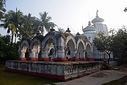 Xatnagar Shiva deul rasmancha bilan
 -
 Shiva deul
 -
 Shiva deuldagi haykal
 -
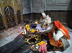 Egradagi Shiva deulning ichki qismi


.jpg)

Egradagi Egra bo'linma kasalxonasi 68 o'rinli bo‘lgan. Egra Superspeciality kasalxonasi. Va u yerda juda ko'p xususiy uy-joylar mavjud
Manbalar
- ↑ Falling Rain Genomics, Inc - Egra
- ↑ „District Statistical Handbook 2014 Purba Medinipur“. Tables 2.1, 2.2. Department of Statistics and Programme Implementation, Government of West Bengal. 2019-yil 21-yanvarda asl nusxadan arxivlangan. Qaraldi: 2019-yil 17-aprel.
- ↑ „Egra PS“. Purba Medinipur District Police. 2017-yil 11-yanvarda asl nusxadan arxivlangan. Qaraldi: 2016-yil 10-noyabr.
- ↑ „District Statistical Handbook 2014 Purba Medinipur“. Table 2.2. Department of Planning and Statistics, Government of West Bengal. 2019-yil 21-yanvarda asl nusxadan arxivlangan. Qaraldi: 2019-yil 17-aprel.
- ↑ „2011 Census – Primary Census Abstract Data Tables“. West Bengal – District-wise. Registrar General and Census Commissioner, India. Qaraldi: 2016-yil 15-iyul.
- ↑ „Census of India 2001: Data from the 2001 Census, including cities, villages and towns (Provisional)“. Census Commission of India. 2004-yil 16-iyunda asl nusxadan arxivlangan. Qaraldi: 2008-yil 1-noyabr.
- ↑ „Egra Sarada Sashi Bhusan College“. ESSBC. Qaraldi: 2019-yil 17-aprel.
- ↑ McCutchion, David J., Late Mediaeval Temples of Bengal, first published 1972, reprinted 2017, pages 40, 41, 69.
Havolalar
Cities, towns, locations and neighbourhoods in East Midnapore District, Medinipur division | ||||||||||
|---|---|---|---|---|---|---|---|---|---|---|
| Cities, municipal and census towns |
|  | ||||||||
| Locations other than cities and towns |
| |||||||||
| Neighbourhoods |
| |||||||||
| Related topics | ||||||||||





Andoza:Temple towns in West Bengal
 | Bu maqola birorta turkumga qoʻshilmagan. Iltimos, maqolaga aloqador turkumlar qoʻshib yordam qiling. (avgust 2024) |