Fayl:Wetterspitze Feuerspitze.jpg
Qiyofa
ZiyoSfera, erkin ensiklopediya
Bu prevyuning hajmi: 800 × 600 piksel. Boshqa oʻlchamlari: 1 600 × 1 200 piksel.
Asl fayl (1 600 × 1 200 piksel, fayl hajmi: 725 KB, MIME tipi: image/jpeg)
Ushbu fayl Vikiomborga yuklangan boʻlib, boshqa loyihalarda ham qoʻllanilishi mumkin. Uning tavsif sahifasidan olingan maʼlumot quyida keltirilgan.
Qisqa izoh
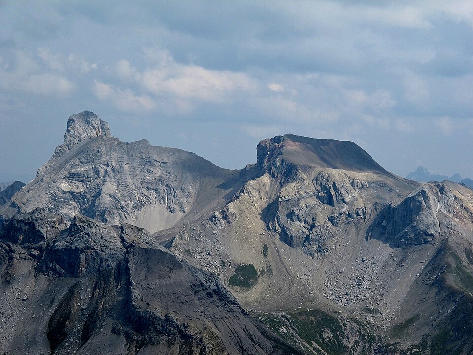
| TaʼrifWetterspitze Feuerspitze.jpg | Holzgauer Wetterspitze (left) and Feuerspitze in the Lechtaler Alps, picture taken from southwest, from Fallensinspitze (2769 m) |
| Sanasi | |
| Manba | photo taken by Kogo |
| Muallif | Kogo |
| Ruxsat (Bu faylning takror foydalanilishi) |
GFDL |
| Camera location | 47° 10′ 53,14″ N, 10° 18′ 00,66″ E | View this and other nearby images on: OpenStreetMap |
|---|
Litsenziyalash
I, the copyright holder of this work, hereby publish it under the following license:
| Ushbu hujjatdan nusxa ko‘chirish, tarqatish va/yoki o‘zgartirish uchun GNU Erkin guvohnoma litsenziyasi (GNU Free Documentation License), 1.2 va har qanday keyingi versiyalar shartlariga muvofiq ruxsat berilgan yoki Ochiq kodli dasturlar jamiyati (Free Software Foundation) tomonidan chop etilgan; oʻzgarmas boʻlimlarsiz, oldingi muqova matnlari va orqa muqova matnlarisiz. Litsenziya nusxasi GNU Erkin guvohnoma litsenziyasi (GNU Free Documentation License) boʻlimiga kiritilgan.http://www.gnu.org/copyleft/fdl.htmlGFDLGNU Free Documentation Licensetruetrue |
| Annotations InfoField | This image is annotated: View the annotations at Commons |
1412
532
14
14
1600
1200
Große Schlenkerspitze 2833 m
Captions
Add a one-line explanation of what this file represents
Holzgauer Wetterspitze (links) und Feuerspitze von der Fallensinspitze (2769 m)
Items portrayed in this file
tasvirlangan obyekt
some value
12 avgust 2000
captured with inglizcha
Canon PowerShot G11 inglizcha
coordinates of the point of view inglizcha
47°10'53.144"N, 10°18'0.659"E
exposure time inglizcha
0,00125 soniya
f-number inglizcha
5,6
focal length inglizcha
30,5 millimetr
ISO speed inglizcha
80
image/jpeg
Fayl tarixi
Faylning biror paytdagi holatini koʻrish uchun tegishli sana/vaqtga bosingiz.
| Sana/Vaqt | Miniatura | Oʻlchamlari | Foydalanuvchi | Izoh | |
|---|---|---|---|---|---|
| joriy | 22:18, 2013-yil 9-may | 1 600 × 1 200 (725 KB) | wikimediacommons>Kogo |
Fayllarga ishoratlar
Bu faylga quyidagi sahifa bogʻlangan:
Metama’lumot
Bu fayl qoʻshimcha maʼlumotlarni oʻz ichiga oladi, ehtimol uni tuzish yoxud raqamlashtirish uchun raqamli kamera yoki skanerdan foydalanilgan.
Agar fayl asl holatidan oʻzgartirilgan boʻlsa, baʼzi tafsilotlar oʻzgartirilgan faylni toʻliq aks ettirmasligi mumkin.
| Camera manufacturer | Canon |
|---|---|
| Camera model | Canon PowerShot G11 |
| Exposure time | 1/800 sec (0,00125) |
| F Number | f/5,6 |
| ISO speed rating | 80 |
| Date and time of data generation | 13:03, 2012-yil 11-sentyabr |
| Lens focal length | 30,5 mm |
| Latitude | 47° 10′ 53,14″ N |
| Longitude | 10° 18′ 0,66″ E |
| Altitude | 2 771,38 meters above sea level |
| City shown | Kaisers |
| Width | 1 600 piksel |
| Height | 1 200 piksel |
| Compression scheme | Uncompressed |
| Pixel composition | RGB |
| Orientation | Normal |
| Horizontal resolution | 180 dpi |
| Vertical resolution | 180 dpi |
| Data arrangement | chunky format |
| Software used | Zoner Photo Studio 15 |
| File change date and time | 19:15, 2013-yil 9-may |
| Y and C positioning | Centered |
| Exif version | 2.21 |
| Date and time of digitizing | 13:03, 2012-yil 11-sentyabr |
| Meaning of each component |
|
| Image compression mode | 3 |
| APEX shutter speed | 9,65625 |
| APEX aperture | 4,96875 |
| APEX exposure bias | −0,33333333333333 |
| Maximum land aperture | 4,34375 APEX (f/4,51) |
| Metering mode | Pattern |
| Flash | Flash did not fire, compulsory flash suppression |
| Supported Flashpix version | 1 |
| Color space | sRGB |
| Focal plane X resolution | 12 493,150684932 |
| Focal plane Y resolution | 12 493,150684932 |
| Focal plane resolution unit | inches |
| Sensing method | One-chip color area sensor |
| File source | Digital still camera |
| Custom image processing | Normal process |
| Exposure mode | Manual exposure |
| White balance | Auto white balance |
| Digital zoom ratio | 1 |
| Scene capture type | Standard |
| GPS time (atomic clock) | 11:03 |
| Geodetic survey data used | WGS-84 |
| GPS date | 2012-yil 11-sentyabr |
| GPS tag version | 0.0.2.2 |
| Supported Flashpix version | 1 |
| Image width | 3 648 piksel |
| Image height | 2 736 piksel |
| Keywords | |
| Code for country shown | AUT |
| Sublocation of city shown | Sankt Jakob |
| Country shown | Österreich |
| Province or state shown | Tirol |