
Fayl:WW2-Holocaust-Poland.PNG

Bu prevyuning hajmi: 557 × 600 piksel. Boshqa oʻlchamlari: 2 007 × 2 161 piksel.
Asl fayl (2 007 × 2 161 piksel, fayl hajmi: 1,34 MB, MIME tipi: image/png)

|
This map image could be re-created using vector graphics as a SVG file. This has several advantages; see Commons:Media for cleanup for more information. If a SVG form of this image is available, please upload it and afterwards replace this template with
{{vector version available|new image name}}.It is recommended to name the SVG file “WW2-Holocaust-Poland.svg”—then the template Vector version available (or Vva) does not need the new image name parameter. |
Qisqa izoh
| Taʼrif |
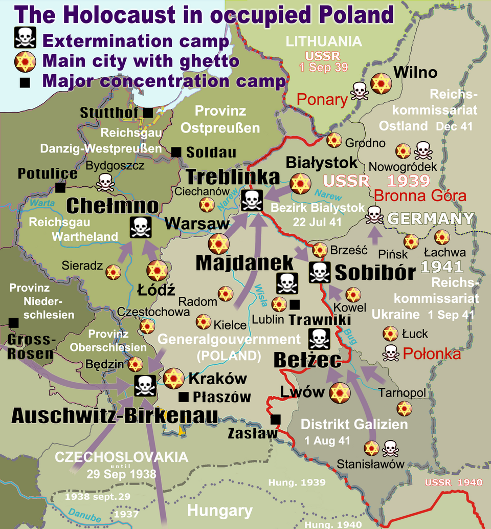
English: Map of the Holocaust in occupied Poland during World War II. The outline shows the borders of the Second Polish Republic at the time of the Nazi-German-and-Soviet invasion of Poland in 1939 with demarcation line between the two invading armies marked in red. Internal boundaries show the administrative divisions of occupied territories imposed by Nazi Germany when the Final Solution was set in motion during and after Operation Barbarossa of 1941. This map shows all Nazi German extermination camps (or death camps), as well as prominent concentration, labour and prison camps, major pre-WW2 Polish cities with the new Jewish ghettos set up by Nazi Germany, major deportation routes, and major massacre sites. Notes: 1. Extermination camps – marked with white skulls in black squares – are six dedicated facilities used for the mass gassings of prisoners, but all camps and ghettos took a toll of many, many lives. 2. Concentration camps – marked with black squares – feature only the most notorious forced-labor camps, prison camps & transit camps. 3. Sites of mass shootings into remote ravines – marked with white skulls – include Bronna Góra, Ponary and others. They were utilized during the 'Holocaust by bullets'. 4. Destruction ghettos – marked with Yellow stars in red circles – existed in most Polish cities. Only a selection is shown. 5. Major deportation routes travelled by the Holocaust trains are marked with RosyBrown arrows. 6. Most camps & ghettos which are not well known have been excluded for clarity. 7. District borders are at the height of Axis domination (1942). 8. Regions have German designations (e.g. "Ostland"), with the country name denoted in uppercase letters, e.g. LITHUANIA, CZECHOSLOVAKIA, or in parenthesis below the German occupational designation, e.g. (POLAND). |
| Sanasi | |
| Manba |
Oʻzimning ishim. Composite map derived from a variety of readily available sources which may or may not include:
|
| Muallif |
|
| Ruxsat (Bu faylning takror foydalanilishi) |
PD, see below. The map is completely unrestricted for any Wikipedia/Wikimedia project. |
| Other versions |
[]
|


.png)


.png)




Litsenziyalash
For all derivative works of maps uploaded earlier see below.
Poeticbent (en), the copyright holder of this work, hereby publishes it under the following license:

|
This work has been released into the public domain by its author, Poeticbent (en). This applies worldwide. In some countries this may not be legally possible; if so: Poeticbent (en) grants anyone the right to use this work for any purpose, without any conditions, unless such conditions are required by law. |
- File uploaded previously
Dennis Nilsson, the copyright holder of this work, hereby publishes it under the following license:


This file is licensed under the Creative Commons Attribution 3.0 Unported license.
Attributsiya:
Dennis Nilsson
- Siz erkinsiz:
- ulashishga – ishlanmani nusxalash, tarqatish va uzatish
- remiks qilishga – ishni moslashtirishga
- Quyidagi shartlar asosida:
- atribut – Siz tegishli litsenziyaga havolani taqdim etishingiz va oʻzgartirishlar kiritilganligini koʻrsatishingiz kerak. Siz buni har qanday oqilona yoʻl bilan qilishingiz mumkin, lekin litsenziar Sizni yoki Sizning foydalanishingizni ma'qullashini taklif qiladigan tarzda emas.
Derivative work: Piotr Konieczny aka Prokonsul Piotrus Talk Derivative works of this file:
Derivative work: User:Poeticbent (Talk) Derivative works of this file:
- Uploaded previously
 |
This is a retouched picture, which means that it has been digitally altered from its original version. Modifications: Smaller version: occupied Poland only (pre-WWII borders). The original can be viewed here: WW2-Holocaust-Europe.png:  . .
|
I, the copyright holder of this work, hereby publish it under the following license:
This file is licensed under the Creative Commons Attribution 3.0 Unported license.
- Siz erkinsiz:
- ulashishga – ishlanmani nusxalash, tarqatish va uzatish
- remiks qilishga – ishni moslashtirishga
- Quyidagi shartlar asosida:
- atribut – Siz tegishli litsenziyaga havolani taqdim etishingiz va oʻzgartirishlar kiritilganligini koʻrsatishingiz kerak. Siz buni har qanday oqilona yoʻl bilan qilishingiz mumkin, lekin litsenziar Sizni yoki Sizning foydalanishingizni ma'qullashini taklif qiladigan tarzda emas.
Original upload log
For derivative works of the first uploaded file created by User:Dna-webmaster see the following:
- File:WW2-Holocaust-Europe.png licensed with Cc-by-3.0
Uploaded with derivativeFX
Fayl tarixi
Faylning biror paytdagi holatini koʻrish uchun tegishli sana/vaqtga bosingiz.
| Sana/Vaqt | Miniatura | Oʻlchamlari | Foydalanuvchi | Izoh | |
|---|---|---|---|---|---|
| joriy | 20:46, 2020-yil 10-mart | | 2 007 × 2 161 (1,34 MB) | wikimediacommons>Claude Zygiel | Cosmetics |
Fayllarga ishoratlar
Bu faylga quyidagi 2 sahifalar bogʻlangan:
