
Fayl:Ukraine famine map.png

Bu prevyuning hajmi: 800 × 490 piksel. Boshqa oʻlchamlari: 2 848 × 1 744 piksel.
Asl fayl (2 848 × 1 744 piksel, fayl hajmi: 680 KB, MIME tipi: image/png)

|
This map image could be re-created using vector graphics as a SVG file. This has several advantages; see Commons:Media for cleanup for more information. If a SVG form of this image is available, please upload it and afterwards replace this template with
{{vector version available|new image name}}.It is recommended to name the SVG file “Ukraine famine map.svg”—then the template Vector version available (or Vva) does not need the new image name parameter. |
Qisqa izoh
| Taʼrif |
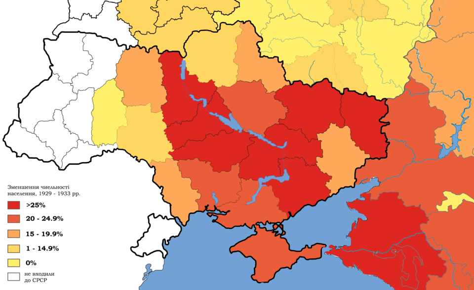
Українська: Зменшення кількості населення на українських землях, що входили до складу СРСР протягом 1929 - 1933 рр. Результат колективізації та масових репресій які завершилися Голодомором English: Depopulation in Ukraine and southern Russia (mainly in region of Kuban, which at that time was entirely populated by Ukrainians) 1929 – 1933. White regions were not part of the USSR at that time. As a result of collectivization and mass repressions that ended with the Holodomor and the death of millions. This fact was taboo in the Soviet Union and forbidden to discuss until its collapse. Español: Un indicador de cómo la población de las tierras ucranianas que formaban parte de la URSS disminuyó entre 1929 y 1933. El sur de Rusia (especialmente el Kuban, que entonces estaba completamente poblado por ucranianos) también sufrió significativamente. Como resultado de la colectivización y las represiones masivas, que terminaron con el Holodomor y la muerte de millones. Este tema era tabú en la Unión Soviética y estaba prohibido hablar de él hasta su colapso. |
| Sanasi | |
| Manba | Oʻzimning ishim, based on: File:Map_of_Ukraine_political_simple_blank.png, File:Belarus_provinces_blank.png, File:Outline_Map_of_Central_Russia.svg, File:Ouline_Map_of_Southern_Federal_District.svg, statistics from "The Foreign Office and the famine : British documents on Ukraine and the Great Famine of 1932-1933" / edited by Marco Carynnyk, Lubomyr Y. Luciuk and Bohdan S. Kordan ; with a foreword by Michael R. Marrus. Kingston, Ont. ; Vestal, N.Y. : Limestone Press, 1988. lxi, 493 p. ; 24 p. ISBN 0919642314 |
| Muallif | Sergento |
| Other versions |
|



Litsenziyalash
I, the copyright holder of this work, hereby publish it under the following license:


This file is licensed under the Creative Commons Attribution-Share Alike 4.0 International license.
- Siz erkinsiz:
- ulashishga – ishlanmani nusxalash, tarqatish va uzatish
- remiks qilishga – ishni moslashtirishga
- Quyidagi shartlar asosida:
- atribut – Siz tegishli litsenziyaga havolani taqdim etishingiz va oʻzgartirishlar kiritilganligini koʻrsatishingiz kerak. Siz buni har qanday oqilona yoʻl bilan qilishingiz mumkin, lekin litsenziar Sizni yoki Sizning foydalanishingizni ma'qullashini taklif qiladigan tarzda emas.
- bir xil ulashish – Agar Siz materialni remiks qilsangiz, oʻzgartirsangiz yoki unga asoslansangiz, oʻz hissalaringizni asl nusxadagi kabi bir xil yoki mos litsenziya ostida tarqatishingiz kerak.
Fayl tarixi
Faylning biror paytdagi holatini koʻrish uchun tegishli sana/vaqtga bosingiz.
| Sana/Vaqt | Miniatura | Oʻlchamlari | Foydalanuvchi | Izoh | |
|---|---|---|---|---|---|
| joriy | 23:21, 2014-yil 8-noyabr | | 2 848 × 1 744 (680 KB) | wikimediacommons>Sergento | User created page with UploadWizard |
Fayllarga ishoratlar
Bu faylga quyidagi sahifa bogʻlangan:
