
Fayl:Tadrart01.JPG

Bu prevyuning hajmi: 800 × 533 piksel. Boshqa oʻlchamlari: 2 560 × 1 707 piksel | 3 072 × 2 048 piksel.
Asl fayl (3 072 × 2 048 piksel, fayl hajmi: 1,53 MB, MIME tipi: image/jpeg)
Qisqa izoh
| Taʼrif |
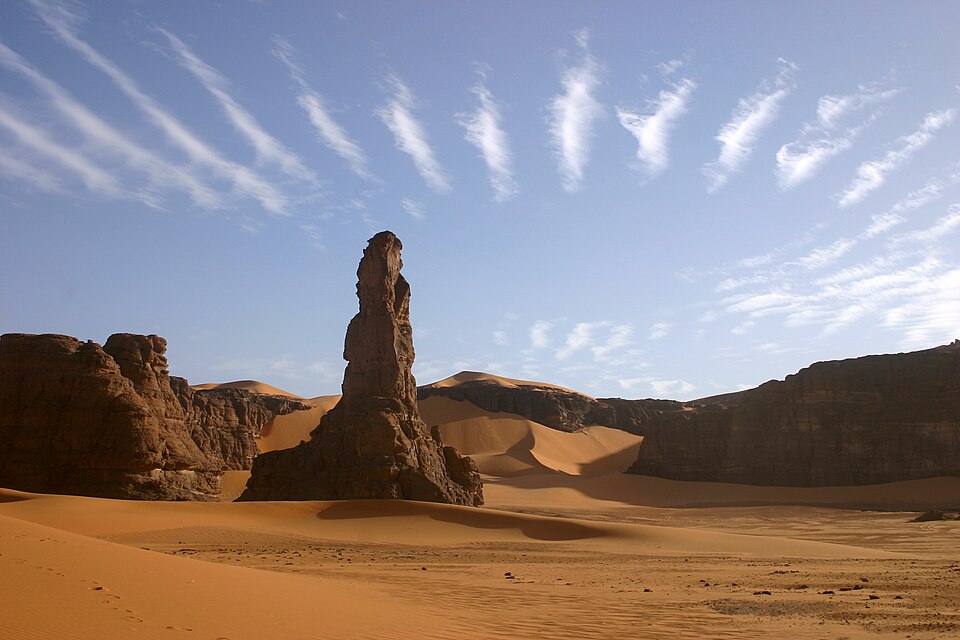
العربية: صورة لموقع صاحب الناقة في منطقة تدرارت أكاكوس، في جنوب شرق الجزائر، وتظهر في السماء سُحب متموِّجة.
English: The Moul n'ga Cirque in the Tadrart region, Southeast Algeria, with wave clouds above. The wave cloud formation is caused by sinusoidial oscillations in an air mass moving over a large obstacle. Condensation occurs as the wave peaks enter a colder environment at higher altitude
Français : Le cirque de moul n'ga dans la Tadrart (sud est Algérie)
ⵜⴰⵎⴰⵣⵉⵖⵜ : ⵉⴷⵓⵔⴰⵔ ⵏ ⴰⴽⴰⴽⵓⵙ ⵜⴰⵎⴰ ⵏ ⵜⴰⴷⵔⴰⵔⵜ (ⴰⵜⴰⵔⴰⵎ ⵏ ⴷⵣⴰⵢⵔ) |
| Sanasi | 28 fevral 2006 (according to Exif data) |
| Manba | Oʻzimning ishim |
| Muallif | Pir6mon |
| Other versions | Derivative works of this file: RuleOfThirds-SideBySide.gif |


| Camera location |  | View this and other nearby images on: OpenStreetMap |  |
|---|
Litsenziyalash
I, the copyright holder of this work, hereby publish it under the following licenses:

|
Ushbu hujjatdan nusxa ko‘chirish, tarqatish va/yoki o‘zgartirish uchun GNU Erkin guvohnoma litsenziyasi (GNU Free Documentation License), 1.2 va har qanday keyingi versiyalar shartlariga muvofiq ruxsat berilgan yoki Ochiq kodli dasturlar jamiyati (Free Software Foundation) tomonidan chop etilgan; oʻzgarmas boʻlimlarsiz, oldingi muqova matnlari va orqa muqova matnlarisiz. Litsenziya nusxasi GNU Erkin guvohnoma litsenziyasi (GNU Free Documentation License) boʻlimiga kiritilgan. |
  
|
Bu fayl Creative Commons asosida litsenziyalangan Attribution- Share Alike 3.0 Unported litsenziyasi. | |
| ||
| This licensing tag was added to this file as part of the GFDL licensing update. |

This file is licensed under the Creative Commons Attribution-Share Alike 2.5 Generic, 2.0 Generic and 1.0 Generic license.
- Siz erkinsiz:
- ulashishga – ishlanmani nusxalash, tarqatish va uzatish
- remiks qilishga – ishni moslashtirishga
- Quyidagi shartlar asosida:
- atribut – Siz tegishli litsenziyaga havolani taqdim etishingiz va oʻzgartirishlar kiritilganligini koʻrsatishingiz kerak. Siz buni har qanday oqilona yoʻl bilan qilishingiz mumkin, lekin litsenziar Sizni yoki Sizning foydalanishingizni ma'qullashini taklif qiladigan tarzda emas.
- bir xil ulashish – Agar Siz materialni remiks qilsangiz, oʻzgartirsangiz yoki unga asoslansangiz, oʻz hissalaringizni asl nusxadagi kabi bir xil yoki mos litsenziya ostida tarqatishingiz kerak.
Siz oʻzingiz xohlagan litsenziyani tanlashingiz mumkin.
|




|
This image was selected as picture of the day on Wikimedia Commons for 3 December 2006. It was captioned as follows: Other languages:
Čeština: Skalní útvar Moul N'Aga v pouštní oblasti Tadrart Acacus v jihovýchodním Alžírsku Cymraeg: Moul N'Aga yn Tadrart Acacus, de-ddwyrain Algeria Español: Moul N'Aga en Tadrart Acacus en el sudeste de Algeria Français : Le cirque de Moul n'ga dans la Tadrart (sud-est de l'Algérie). Italiano: Moul N'Aga a Tadrart, sud est dell'Algeria. Magyar: Moul N'Aga a Tadrart Acacus sivatagban, Algéria délkeleti részén Português: Moul N'Aga, Tadrart Acacus, no sueste da Argélia Sicilianu: Moul N'Aga a Tadrart, sud est di l'Algirìa. Slovenčina: Skalný útvar Moul N'Aga v púštnej oblasti Tadrart Acacus v juhovýchodnom Alžírsku Svenska: Moul n'Aga i Tadrart i sydöstra Algeriet. Türkçe: Tadrart Acacus bölgesinde Moul N'Aga kaya oluşumu, Cezayir'in güneydoğusu Русский: Мол Н'ага в Тадрарт Акакусе на юго-востоке Алжира 中文: 阿尔及利亚东南部塔德拉尔的莫兰尕盆地谷。 |
Fayl tarixi
Faylning biror paytdagi holatini koʻrish uchun tegishli sana/vaqtga bosingiz.
| Sana/Vaqt | Miniatura | Oʻlchamlari | Foydalanuvchi | Izoh | |
|---|---|---|---|---|---|
| joriy | 01:11, 2006-yil 25-iyul | | 3 072 × 2 048 (1,53 MB) | wikimediacommons>Pir6mon | Le cirque de moul n'ga dans la Tadrart (sud est Algérie) Category:desert |
Fayllarga ishoratlar
Bu faylga quyidagi sahifa bogʻlangan:
