Kontent qismiga oʻtish

Fayl:Political map of Canada.png

ZiyoSfera, erkin ensiklopediya
Asl fayl (1 280 × 1 107 piksel, fayl hajmi: 245 KB, MIME tipi: image/png)

Ushbu fayl Vikiomborga yuklangan boʻlib, boshqa loyihalarda ham qoʻllanilishi mumkin. Uning tavsif sahifasidan olingan maʼlumot quyida keltirilgan.

Qisqa izoh

Taʼrif
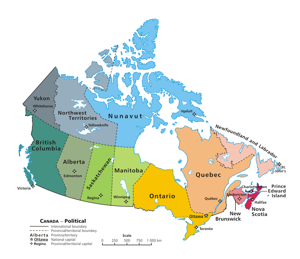
English: A map of Canada exhibiting its ten provinces and three territories, and their capitals. (Lambert conformal conic projection from The Atlas of Canada)
Українська: Проекція Ламберта з атласа Канади. Мапа Канади з її десятьма провінціями, трьома теріторіями та їх столицями.
Sanasi
Manba Oʻzimning ishim
Muallif E Pluribus Anthony, transferred to Wikimedia Commons by Kaveh (log), optimized by Andrew pmk.
Other versions

Derivative works of this file:

File:Political map of Canada_ms.svg
File:Political map of Canada.svg is a vector version of this file. It should be used in place of this PNG file when not inferior.

File:Political map of Canada.png → File:Political map of Canada.svg

For more information, see Help:SVG.

In other languages
Alemannisch ∙ العربية ∙ беларуская (тарашкевіца) ∙ български ∙ বাংলা ∙ català ∙ нохчийн ∙ čeština ∙ dansk ∙ Deutsch ∙ Ελληνικά ∙ English ∙ British English ∙ Esperanto ∙ español ∙ eesti ∙ euskara ∙ فارسی ∙ suomi ∙ français ∙ Frysk ∙ galego ∙ Alemannisch ∙ עברית ∙ हिन्दी ∙ hrvatski ∙ magyar ∙ հայերեն ∙ Bahasa Indonesia ∙ Ido ∙ italiano ∙ 日本語 ∙ ქართული ∙ 한국어 ∙ lietuvių ∙ македонски ∙ മലയാളം ∙ Bahasa Melayu ∙ မြန်မာဘာသာ ∙ norsk bokmål ∙ Plattdüütsch ∙ Nederlands ∙ norsk nynorsk ∙ norsk ∙ occitan ∙ polski ∙ prūsiskan ∙ português ∙ português do Brasil ∙ română ∙ русский ∙ sicilianu ∙ Scots ∙ slovenčina ∙ slovenščina ∙ српски / srpski ∙ svenska ∙ தமிழ் ∙ ไทย ∙ Türkçe ∙ татарча / tatarça ∙ українська ∙ vèneto ∙ Tiếng Việt ∙ 中文 ∙ 中文(中国大陆) ∙ 中文(简体) ∙ 中文(繁體) ∙ 中文(马来西亚) ∙ 中文(新加坡) ∙ 中文(臺灣) ∙ +/−
New SVG image

Litsenziyalash

This work has been released into the public domain by its author, E Pluribus Anthony, at the inglizcha Vikipediya project. This applies worldwide.

In case this is not legally possible:
E Pluribus Anthony grants anyone the right to use this work for any purpose, without any conditions, unless such conditions are required by law.

Annotations
InfoField
This image is annotated: View the annotations at Commons

Captions

Add a one-line explanation of what this file represents
This file represents the political map of canada

Items portrayed in this file

tasvirlangan obyekt

6 iyun 2006

image/png

Fayl tarixi

Faylning biror paytdagi holatini koʻrish uchun tegishli sana/vaqtga bosingiz.

Sana/VaqtMiniaturaOʻlchamlariFoydalanuvchiIzoh
joriy07:50, 2007-yil 13-iyun07:50, 2007-yil 13-iyun dagi versiya uchun tasvir1 280 × 1 107 (245 KB)wikimediacommons>Andrew pmk~commonswikioptimize png

Bu faylga quyidagi sahifa bogʻlangan: