
Fayl:Malaria map.PNG

Bu prevyuning hajmi: 800 × 352 piksel. Boshqa oʻlchamlari: 1 427 × 628 piksel.
Asl fayl (1 427 × 628 piksel, fayl hajmi: 39 KB, MIME tipi: image/png)


|
This health map image could be re-created using vector graphics as a SVG file. This has several advantages; see Commons:Media for cleanup for more information. If a SVG form of this image is available, please upload it and afterwards replace this template with
{{vector version available|new image name}}.It is recommended to name the SVG file “Malaria map.svg”—then the template Vector version available (or Vva) does not need the new image name parameter. |
Qisqa izoh
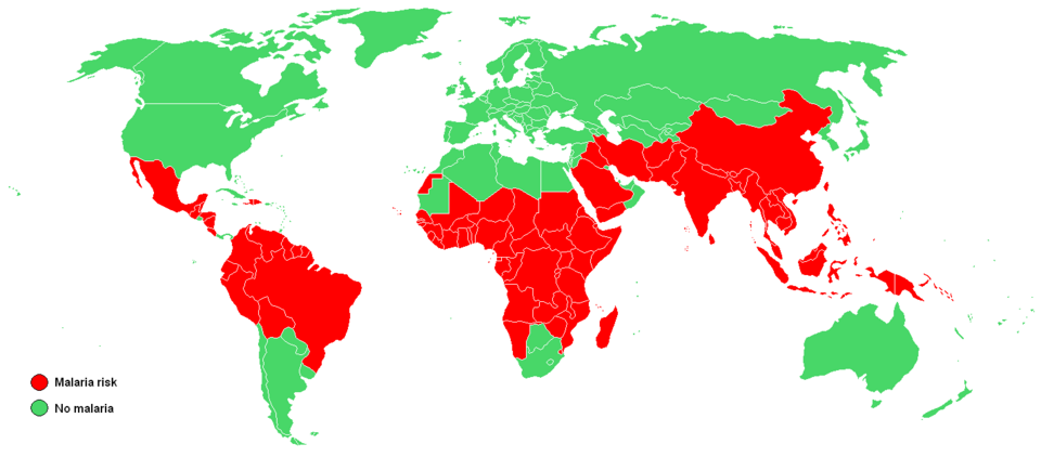
Map shows the countries where malaria is known to occur as of 2003. Malaria is usually restricted to tropical and subtropical areas (see map) and altitudes below 1,500 m. Data from the United States Centers for Disease Control[dead link]
Litsenziyalash

|
This work has been released into the public domain by its author, Petaholmes. This applies worldwide. In some countries this may not be legally possible; if so: |
Fayl tarixi
Faylning biror paytdagi holatini koʻrish uchun tegishli sana/vaqtga bosingiz.
| Sana/Vaqt | Miniatura | Oʻlchamlari | Foydalanuvchi | Izoh | |
|---|---|---|---|---|---|
| joriy | 07:22, 2015-yil 2-mart | | 1 427 × 628 (39 KB) | wikimediacommons>Leftcry | South Sudan |
Fayllarga ishoratlar
Bu faylga quyidagi sahifa bogʻlangan:
