
Fayl:LacAnnecy.jpg


| Taʼrif |
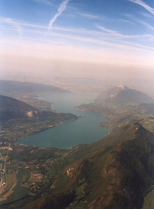
fr:Lac d'Annecy - vue d'avion au sud du lac - (c) 2003, Didier Halatre. La photo a été prise d'avion, à la verticale de fr:Faverges à 10 500' (env. 3 200 m) vers le nord, mi-septembre 2003. Temps beau mais brumeux dans le lointain. fr:Image:LacAnnecy.jpg fr:Image:LacAnnecy_pt_com.jpg On distingue bien le « petit lac » au premier plan du « grand lac » en arrière. La séparation est marquée à gauche (ouest) par le Taillefer qui donne la presqu'île de fr:Duingt (le point blanc est la château de Duingt !), et à droite (est) par le Roc de Chère. Au point de vue massif, à gauche (ouest), on a le fr:massif des Bauges, avec sur la photo le Taillefer avec juste derrière le début du Roc des Boeufs, et en arrière plan le fr:Semnoz. À droite (est), on a le fr:massif des Bornes, à droite en vert clair, il y a le Col de la Forclaz, le massif important en arrière-plan est le Mont Veyrier. fr:Annecy et fr:Annecy-le-Vieux se distinguent légèrement dans la brume, au nord du lac (en haut de la photo) entre le Semnoz et le Mont Veyrier. |
| Manba | Oʻzimning ishim |
| Muallif | User Didier on fr.wikipedia |
| Ruxsat (Bu faylning takror foydalanilishi) |
Released under the GNU Free Documentation License. |
| Other versions |
Originally from fr.wikipedia; description page is (was) here * 27 septembre 2003 à 15:45 [[:fr:User:Didier|Didier]] 320×435 (15 541 octets) <span class="comment">(Lac d'Annecy - vue d'avion au sud du lac - (c) 2003 Didier Halatre, sous licence GNU FDL)</span> |


|
Ushbu hujjatdan nusxa ko‘chirish, tarqatish va/yoki o‘zgartirish uchun GNU Erkin guvohnoma litsenziyasi (GNU Free Documentation License), 1.2 va har qanday keyingi versiyalar shartlariga muvofiq ruxsat berilgan yoki Ochiq kodli dasturlar jamiyati (Free Software Foundation) tomonidan chop etilgan; oʻzgarmas boʻlimlarsiz, oldingi muqova matnlari va orqa muqova matnlarisiz. Litsenziya nusxasi GNU Erkin guvohnoma litsenziyasi (GNU Free Documentation License) boʻlimiga kiritilgan. |
  
|
Bu fayl Creative Commons asosida litsenziyalangan Attribution- Share Alike 3.0 Unported litsenziyasi. | |
| ||
| This licensing tag was added to this file as part of the GFDL licensing update. |
(Uploaded using CommonsHelper or PushForCommons)
| Annotations | This image is annotated: View the annotations at Commons |
Fayl tarixi
Faylning biror paytdagi holatini koʻrish uchun tegishli sana/vaqtga bosingiz.
| Sana/Vaqt | Miniatura | Oʻlchamlari | Foydalanuvchi | Izoh | |
|---|---|---|---|---|---|
| joriy | 14:26, 2007-yil 7-yanvar | | 1 024 × 1 393 (101 KB) | wikimediacommons>Bilou~commonswiki |
Fayllarga ishoratlar
Bu faylga quyidagi sahifa bogʻlangan:
