
Fayl:Korean war 1950-1953.gif

Bu prevyuning hajmi: 387 × 600 piksel. Boshqa oʻlchamlari: 562 × 871 piksel.
Asl fayl (562 × 871 piksel, fayl hajmi: 1,32 MB, MIME tipi: image/gif, looped, 20 frames, 30 soniya)



Qisqa izoh
| Taʼrif |
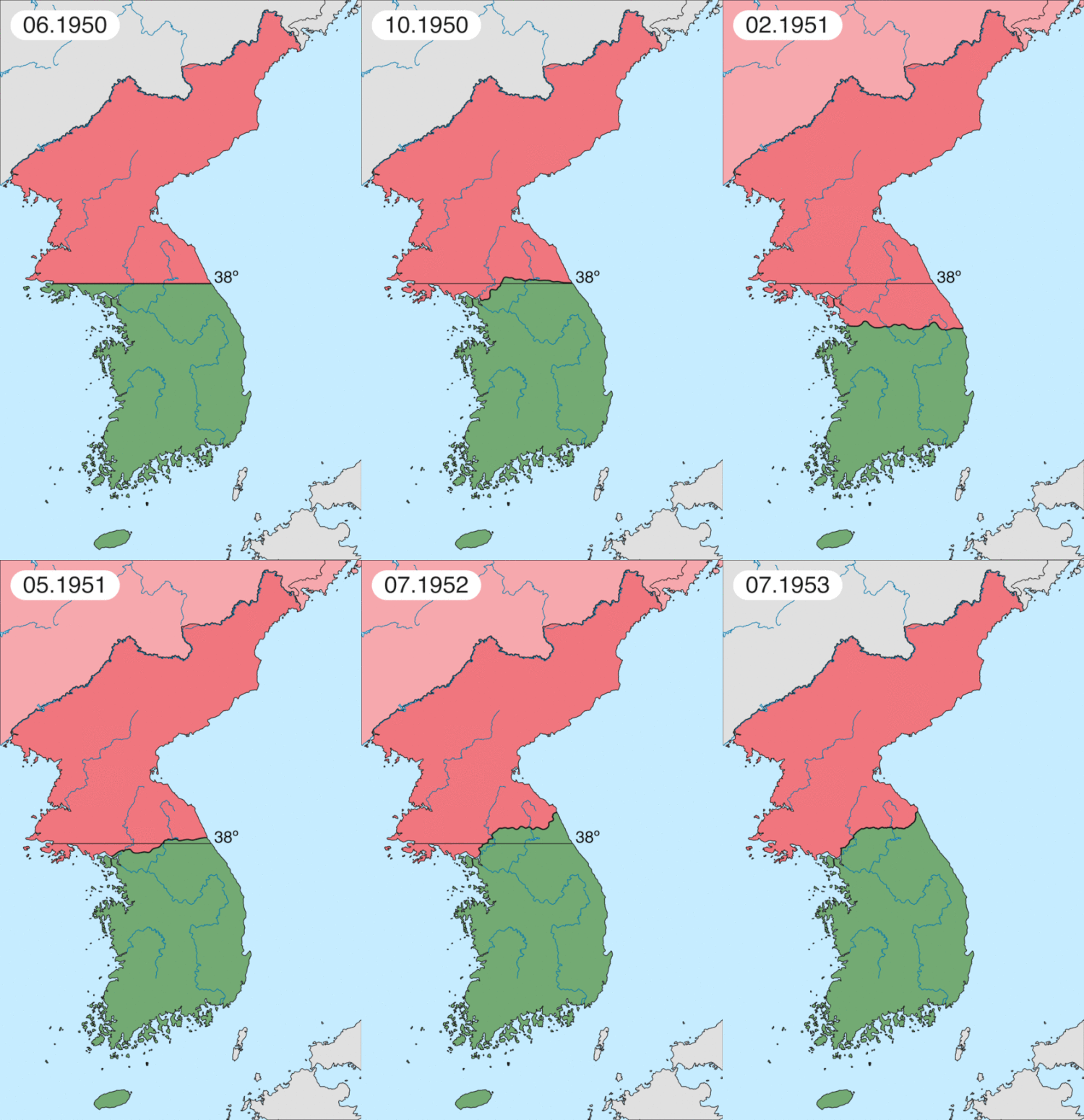
Deutsch: Karte des Koreakriegs von Mai 1950 bis Juli 1951, abgebildet:
English: Map of Korean war from May 1950 to July 1951, showing:
Chinese and communist forces (Soviet Union) (light red) North Korean forces (red) South Korean, US and United Nations forces (green). Français : Carte de la guerre de Corée de mai 1950 à juillet 1951, montrant:
Les forces chinoises et communistes (Union Soviétique) (rouge clair) Les forces nord-coréennes (rouge) Les forces sud-coréennes, des États-Unis et des Nations unies (vert). Italiano: Mappa della guerra di Corea dal maggio 1950 al luglio 1951, rappresentante:
Le forze cinesi e comuniste (Unione Sovietica) (rosso chiaro) Le forze nord-coreane (rosso) Le forze sud-coreane, degli Stati Uniti e delle Nazioni Unite (verde). |
| Sanasi | |
| Manba | Oʻzimning ishim |
| Muallif | Leomonaci98 |
Litsenziyalash
I, the copyright holder of this work, hereby publish it under the following licenses:

|
Ushbu hujjatdan nusxa ko‘chirish, tarqatish va/yoki o‘zgartirish uchun GNU Erkin guvohnoma litsenziyasi (GNU Free Documentation License), 1.2 va har qanday keyingi versiyalar shartlariga muvofiq ruxsat berilgan yoki Ochiq kodli dasturlar jamiyati (Free Software Foundation) tomonidan chop etilgan; oʻzgarmas boʻlimlarsiz, oldingi muqova matnlari va orqa muqova matnlarisiz. Litsenziya nusxasi GNU Erkin guvohnoma litsenziyasi (GNU Free Documentation License) boʻlimiga kiritilgan. |
  
|
Bu fayl Creative Commons asosida litsenziyalangan Attribution- Share Alike 3.0 Unported litsenziyasi. | |
| ||
| This licensing tag was added to this file as part of the GFDL licensing update. |
Siz oʻzingiz xohlagan litsenziyani tanlashingiz mumkin.
Fayl tarixi
Faylning biror paytdagi holatini koʻrish uchun tegishli sana/vaqtga bosingiz.
| Sana/Vaqt | Miniatura | Oʻlchamlari | Foydalanuvchi | Izoh | |
|---|---|---|---|---|---|
| joriy | 01:20, 2020-yil 17-fevral | | 562 × 871 (1,32 MB) | wikimediacommons>Leomonaci98 | Graphic update |
Fayllarga ishoratlar
Bu faylga quyidagi sahifa bogʻlangan:
