
Fayl:Klam - Burg Clam (3).JPG

Bu prevyuning hajmi: 800 × 459 piksel. Boshqa oʻlchamlari: 2 560 × 1 468 piksel | 5 300 × 3 040 piksel.

Asl fayl (5 300 × 3 040 piksel, fayl hajmi: 10,71 MB, MIME tipi: image/jpeg)
.JPG)
Qisqa izoh
| Taʼrif |
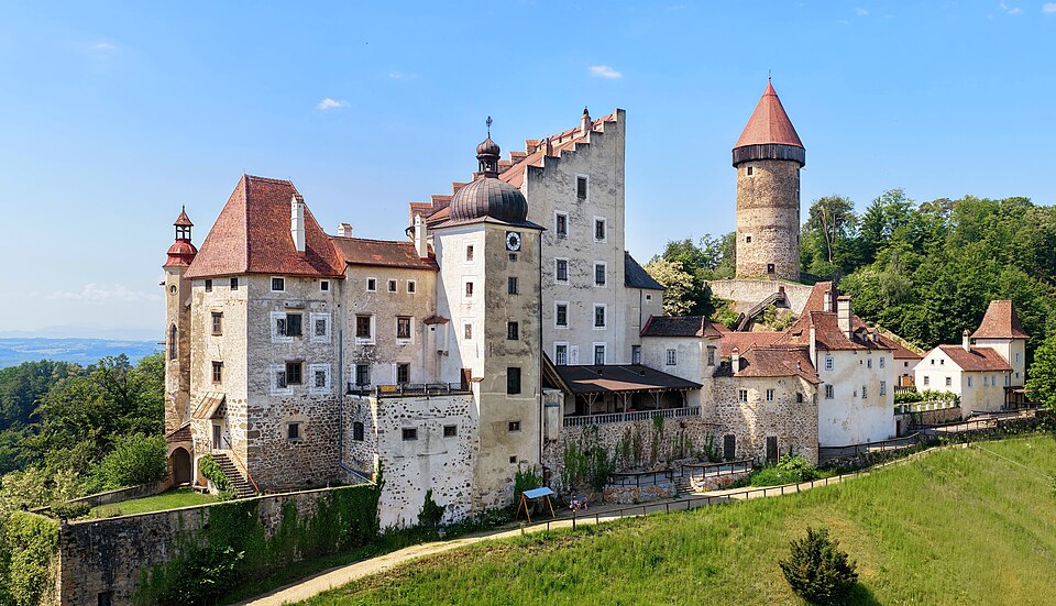
Deutsch: Nordostansicht der Burg Clam in der oberösterreichischen Gemeinde Klam. Die Wehranlage wurde im 12. Jahrhundert errichtet und mehrfach um- und ausgebaut. Der freistehende Rundturm stammt aus dem 13. Jahrhundert.
|
| Sanasi | |
| Manba | Oʻzimning ishim |
| Muallif | C.Stadler/Bwag |
| Ruxsat (Bu faylning takror foydalanilishi) |
Deutsch: Hallo, du darfst meine Fotos kostenlos nutzen, aber nenne mich bitte als Fotograf, beispielsweise „Foto: C.Stadler/Bwag“ oder © C.Stadler/Bwag; CC-BY-SA-4.0. Auf mehr Angaben bestehe ich nicht - im Gegensatz zu manch anderen, die die Vorgaben der unten angeführten Lizenzierung auf Punkt und Beistrich einfordern. English: Feel free to use my photos, but please mention me as the author like © C.Stadler/Bwag or © C.Stadler/Bwag; CC-BY-SA-4.0 (that's good enough) and if you want send me a message: bwag@gmx.net. |
| Object location |  | View this and other nearby images on: OpenStreetMap |  |
|---|
.JPG¶ms=048.220920_N_0014.778490_E_globe:Earth_class:object_type:object__&language=uz)
| Camera location |  | View this and other nearby images on: OpenStreetMap | |
|---|
.JPG¶ms=048.221530_N_0014.780010_E_globe:Earth_type:camera_heading:240.00&language=uz)
Litsenziyalash
I, the copyright holder of this work, hereby publish it under the following license:


This file is licensed under the Creative Commons Attribution-Share Alike 4.0 International license.
- Siz erkinsiz:
- ulashishga – ishlanmani nusxalash, tarqatish va uzatish
- remiks qilishga – ishni moslashtirishga
- Quyidagi shartlar asosida:
- atribut – Siz tegishli litsenziyaga havolani taqdim etishingiz va oʻzgartirishlar kiritilganligini koʻrsatishingiz kerak. Siz buni har qanday oqilona yoʻl bilan qilishingiz mumkin, lekin litsenziar Sizni yoki Sizning foydalanishingizni ma'qullashini taklif qiladigan tarzda emas.
- bir xil ulashish – Agar Siz materialni remiks qilsangiz, oʻzgartirsangiz yoki unga asoslansangiz, oʻz hissalaringizni asl nusxadagi kabi bir xil yoki mos litsenziya ostida tarqatishingiz kerak.
Fayl tarixi
Faylning biror paytdagi holatini koʻrish uchun tegishli sana/vaqtga bosingiz.
| Sana/Vaqt | Miniatura | Oʻlchamlari | Foydalanuvchi | Izoh | |
|---|---|---|---|---|---|
| joriy | 12:23, 2026-yil 1-iyul | | 5 300 × 3 040 (10,71 MB) | wikimediacommons>Bwag | c |
Fayllarga ishoratlar
Bu faylga quyidagi sahifa bogʻlangan:
.JPG)