
Fayl:Historical German linguistical area.PNG

Qisqa izoh



| Taʼrif |
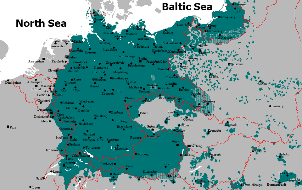
English: The available map is based mainly on the language map "Fischer of the information Atlas Federal Republic of Germany" (Fischer paperback publishing house, S. 63) from the year 1990. Besides calibrations with the "dtv Atlas found to the German language" (German paperbacks publishing house, S. 230/231) and the "Volkskunde - history of the German way of life and culture" (Elard Hugo Meyer, S. 363) from the year 1898 instead of. Furthermore also the books became "the Germanic languages - their history included in fundamentals" (Claus Juergen Hutterer, 1975) of the Akademiai Kiado, "Sudeten German regional studies" (Hans Krebs/Emil Lehmann, 1992), "east Prussian regional studies" (Walther Franz, 1993), all this in the Arndt publishing house appeared to Budapest, "Schlesien regional studies" (Alfred Pudelko, 1993). Also - probably most exact map of the German linguistic area - the dialect map "the spreading of the Germans in Europe had completely large influence 1844-1888" (Heinrich Nabert, 1890), which developed in the course of 30 years and which was presented as reproduction with the federation for German writing and language 1994 (series of publications number 12) again. Furthermore an alignment with the books became "Atlas contemporary history: Europe in 20. Century "(Manfred Scheuch, 1992) appeared in the publishing house Christian Brandstaetter, S. 51, and "small Atlas to German territorial history" (P. 137) of the culture donation of the German refugees (1990), the "Putzger historical world Atlas" (Cornelsen publishing house, 1991) - there S. 99 - made. Furthermore the information of the books "historical and political geography of Europe" (N. J. G. Pounds, the lecturer of the geographical faculty of the University of Cambridge), appeared 1950 in George Westermann publishing house (P. 296, 319, 327), of "Germany borders in history" (Alexander Demandt, 1990) from the publishing house C H. Beck Munich (P. 66) and the language map of "area and population losses of the German Reich and German Austria after the year 1918" (Dr. Karl Hans Ertl, 1996) from the row "German history in 20. Century "of the German publishing house company rose home. For the situation of the German settlement area Pounds on S gives. 295 on: In Czechoslovakia 3.5 millions. In Poland (including Danzigs) 2.2 millions. In Russia 1.6 millions. In France 1.5 millions. In Romania 0.9 millions. In Yugoslavia 0.7 millions. In the Baltic 0.27 millions. In Italy 0.25 millions. In Hungary 0.25 millions and in Belgium 0.15 millions.
Dr. Ertl indicates the following numbers for the tuning areas in west and east Prussia: east Prussia population to 8.10.1919: 577.001 enfranchised: 422.067 voices for Germany: 363.159 (= 97,9%) voices for Poland: 7.924 West Prussia Population to 8.10.1919: 164.183 enfranchised: 121.176 voices for Germany: 96.895 (= 92,4%) voices for Poland: 7.947 For the areas Memel, Soldauer hit a corner, Danzig and environment (retired west Prussia), Brandenburg, Pommern and Posen, which had to be retired without tuning, indicates to Ertl (P. 72) speaker numbers (after native language):
It is also expressly mentioned that according to the official census of the German Reich of the yearly 1914 alone the province west Prussia had a German population portion of over 63%; however in the province floats were those Poland the clear population of majority! But in the time between 1920 and 23 from Poland (above all west Prussia and east Upper Silesia) approximately 1.1 millions Germans were illegally driven out. That had even some objections of the German Reich with the voelkerbund in Geneva according to, since Poland refused those to the German of assured minority rights and/or stepped these with feet! For the retired east Upper Silesia Ertl gives the following numbers to (P. 83): "the voting result was however for Poland and concomitantly for France disappointing (...) (it) obviously it became that with the tuning the majority of the water-Polish speaking population of Upper Silesia had decided for whereabouts with the German Reich. For the German Reich at that time 702,045 voices (= 59.4%) were delivered, for Poland 479,232 (= 40.6%). Only in the circles Beuthen country, large Strelitz, Kattowitz country, Pless, Rybnik and Tarnowitz a weak became (sig!) Polish majority obtains (...)" For the later Sudetenland and the language islands in Zentralboehmen Ertl (P. 146) indicates the following numbers:
(All numbers for 1919, see also for this the representation maps on S. 150/151!) The explanation to the dark-green color ( ): It shows the German settlement areas after the census from 1910, while the state borders were selected of 1937, in order to point out, which area after 1919 from the German Reich and/or from Austria Hungary was separated... agrees there the representation map really minimum with the reality of 1937... however German became there nevertheless still spoken; anyhow isolates still. |
| Sanasi | 14 iyul 2006 (original upload date) |
| Manba | Transferred from en.wikipedia to Commons by GijsvdL using CommonsHelper. |
| Muallif | Rex Germanus at inglizcha Vikipediya |
| Other versions | File:German language in 1910.png (not showing dutch as part of german) |

Litsenziyalash

|
This work has been released into the public domain by its author, Rex Germanus at inglizcha Vikipediya. This applies worldwide. In some countries this may not be legally possible; if so: Rex Germanus grants anyone the right to use this work for any purpose, without any conditions, unless such conditions are required by law. |
Original upload log

- 2006-07-14 09:04 Rex Germanus 1031×651×8 (76660 bytes) == Source proofs and notes == The available map is based mainly on the language map "Fischer of the information Atlas Federal Republic of Germany" (Fischer paperback publishing house, S. 63) from the year 1990. Besides calibrations with the "dtv Atlas fou
Fayl tarixi
Faylning biror paytdagi holatini koʻrish uchun tegishli sana/vaqtga bosingiz.
| Sana/Vaqt | Miniatura | Oʻlchamlari | Foydalanuvchi | Izoh | |
|---|---|---|---|---|---|
| joriy | 23:22, 2015-yil 10-oktyabr | | 1 031 × 651 (63 KB) | wikimediacommons>Spiridon Ion Cepleanu | Correct borders of the time in the south (between France/Italy, Italy/Yugoslavia) and east (Poland/Romania) of the map. |
Fayllarga ishoratlar
Bu faylga quyidagi sahifa bogʻlangan:
