
Fayl:Helsinki Region commrnw.png

Bu prevyuning hajmi: 647 × 600 piksel. Boshqa oʻlchamlari: 2 197 × 2 037 piksel.
Asl fayl (2 197 × 2 037 piksel, fayl hajmi: 1,64 MB, MIME tipi: image/png)

|
This file has been superseded by Helsinki Region rail transport w plans.svg. It is recommended to use the other file. Please note that deleting superseded images requires consensus.
|

|
| Taʼrif |
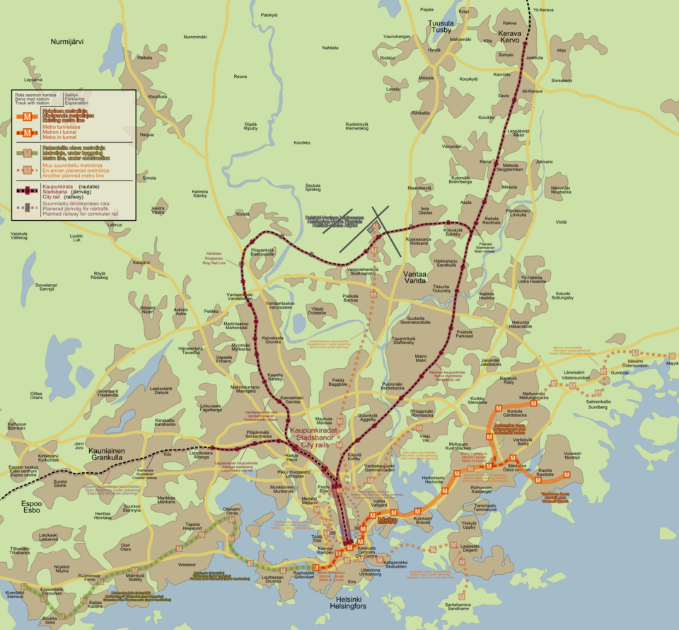
English: Trilingual (Finnish, Swedish, English) map of Helsinki Region commuter rail network with planned extensions (see en:Helsinki commuter rail and en:Helsinki metro). The languages are from top to bottom Finnish, Swedish and English where ever three languages are used. Where only two different names are listed, the top one is Finnish and the bottom one Swedish. The lone names are Finnish ones with no equivalent in other languages
Suomi: Kolmikielinen (suomi, ruotsi, englanti) kartta Helsingin seudun raidelähiliikenneverkosta suunniteltuine laajennuksineen (ks. fi:Pääkaupunkiseudun lähiliikenne ja fi:Helsingin metro)
Svenska: Trespråkig (finska, svenska, engelska) karta över spårnärtrafiksnätverk i Helsingfors Regionen med planerade utsträckningar (se även sv:Huvudstadsregionens närtrafik och sv:Helsingfors tunnelbana) |
||||||||
| Sanasi | |||||||||
| Manba | Oʻzimning ishim | ||||||||
| Muallif | Jyri Lehtinen aka. Oghmoir | ||||||||
| Ruxsat (Bu faylning takror foydalanilishi) |
   This file is licensed under the Creative Commons Attribution-Share Alike 1.0 Generic license.
This file is licensed under the Creative Commons Attribution-Share Alike 2.5 Generic license.
|




Sources
- For Airport metro and Pisararata:
- For Laajasalo metro line:
- For Western metro line:
- For Ring rail:
- For the base map:
- Google Maps (traced over their maps)
SVG source file available here: Image:Helsinki_Region_rail_transport_w_plans.svg
See also: Image:Helsinki metro map 2007.png

Fayl tarixi
Faylning biror paytdagi holatini koʻrish uchun tegishli sana/vaqtga bosingiz.
| Sana/Vaqt | Miniatura | Oʻlchamlari | Foydalanuvchi | Izoh | |
|---|---|---|---|---|---|
| joriy | 11:05, 2015-yil 25-iyul | | 2 197 × 2 037 (1,64 MB) | wikimediacommons>Anhepol | Fixed some own mistakes and added plan of eastern metro extension |
Fayllarga ishoratlar
Bu faylga quyidagi sahifa bogʻlangan:
