
Fayl:Hatay - ethnolinguistic map.svg


Qisqa izoh
| Taʼrif |
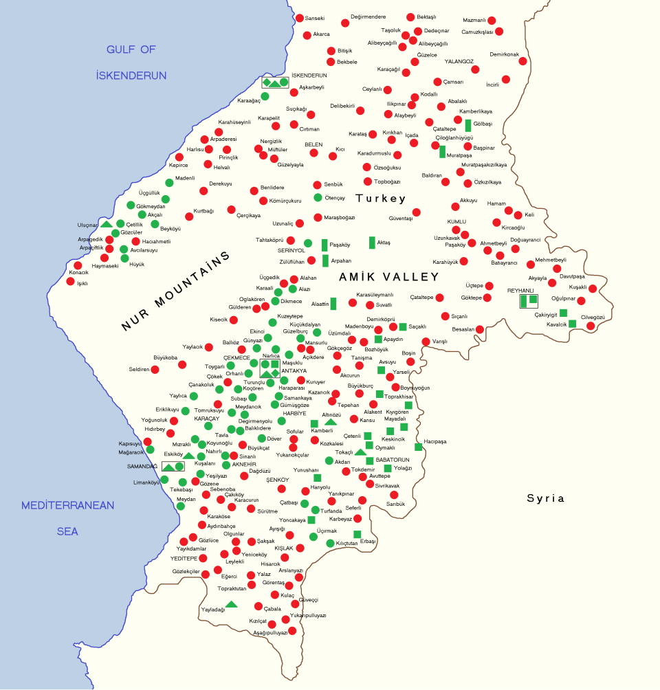
Late 20th-early 21st century language distribution. Turkish (red). Arabic speakers (green) are shown by religious affiliation: Alawite (circle), Christian (triangle), Sunni (square), Bedouin Sunni (rectangle), Jewish (rhombus).
Map data is based on the research of Arnold Werner:
NOTE: My map does not show all existing Hatay settlements and their linguistic composition. Arnold Werner states that his research only covered half of the Arabic speaking villages (some 50 out of a 100). Turkish speaking villages shown on map are those covered by Werner's research. My map is based on Werner's map and data. All locations on my map replicate the geographical placement of locations, as done by Werner. At the time of Werner's publication of his works (early 2000s), a few villages had different names from what they are now and he shows them with those place names. On my map the current names are given of those few places. These settlements are: Soğukoluk > Güzelyayla; Yiğityolu > Karbeyaz; Asi > Aknehir; Güneydam > Turfanda (in this case, old name was restored). |
| Sanasi | |
| Manba | Oʻzimning ishim |
| Muallif | Resnjari |
Litsenziyalash


- Siz erkinsiz:
- ulashishga – ishlanmani nusxalash, tarqatish va uzatish
- remiks qilishga – ishni moslashtirishga
- Quyidagi shartlar asosida:
- atribut – Siz tegishli litsenziyaga havolani taqdim etishingiz va oʻzgartirishlar kiritilganligini koʻrsatishingiz kerak. Siz buni har qanday oqilona yoʻl bilan qilishingiz mumkin, lekin litsenziar Sizni yoki Sizning foydalanishingizni ma'qullashini taklif qiladigan tarzda emas.
- bir xil ulashish – Agar Siz materialni remiks qilsangiz, oʻzgartirsangiz yoki unga asoslansangiz, oʻz hissalaringizni asl nusxadagi kabi bir xil yoki mos litsenziya ostida tarqatishingiz kerak.
Fayl tarixi
Faylning biror paytdagi holatini koʻrish uchun tegishli sana/vaqtga bosingiz.
| Sana/Vaqt | Miniatura | Oʻlchamlari | Foydalanuvchi | Izoh | |
|---|---|---|---|---|---|
| joriy | 09:47, 2020-yil 1-sentyabr | | 2 928 × 3 060 (330 KB) | wikimediacommons>Resnjari | Uploaded own work with UploadWizard |
Fayllarga ishoratlar
Bu faylga quyidagi sahifa bogʻlangan:
