
Fayl:Georgia topographic map-fr.svg

Size of this PNG preview of this SVG file: 707 × 385 piksel. Boshqa oʻlchamlari: 2 560 × 1 394 piksel.
Asl fayl (SVG fayl, asl oʻlchamlari 707 × 385 piksel, fayl hajmi: 3,52 MB)
Qisqa izoh
| Taʼrif |
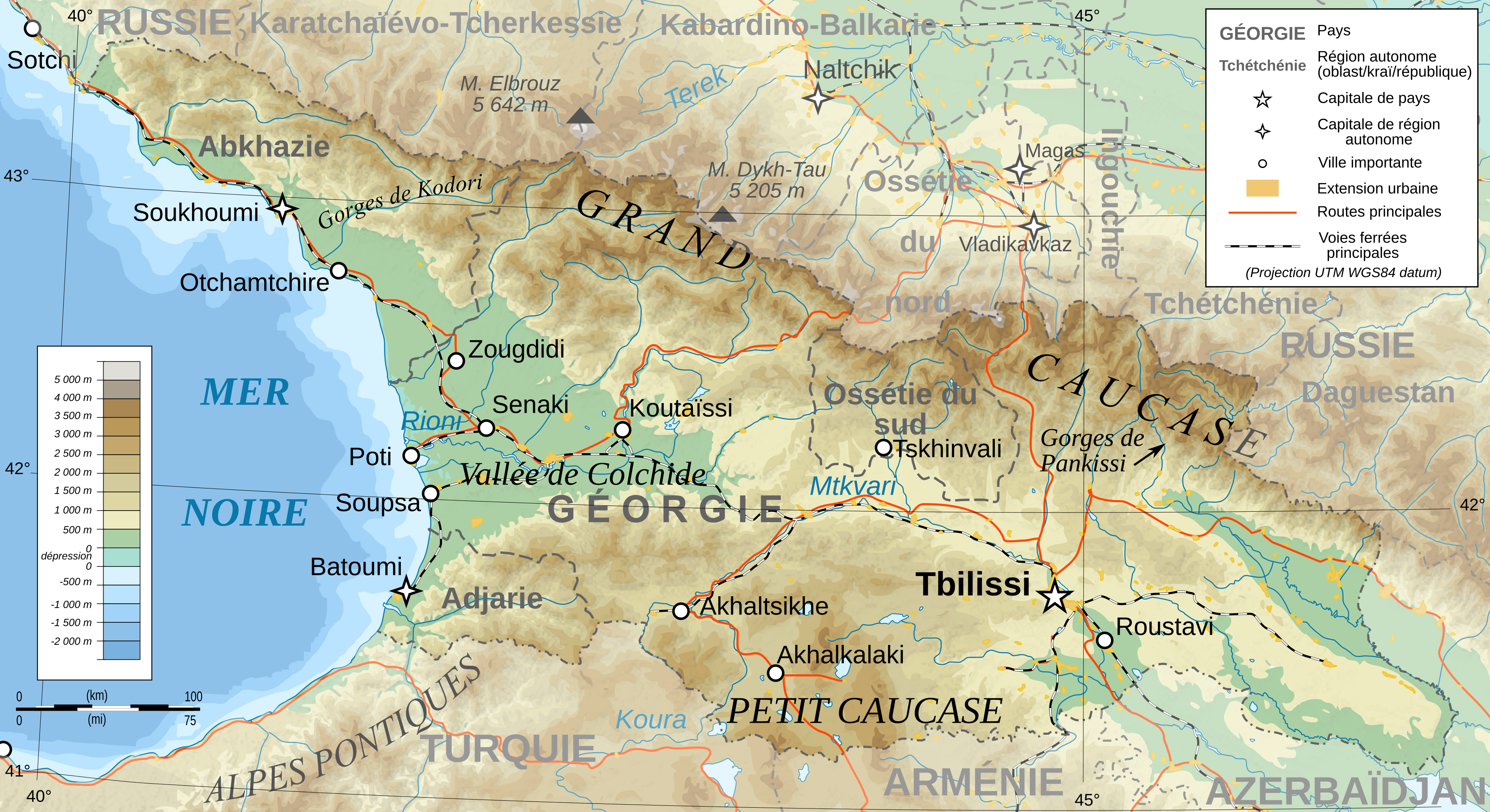
Deutsch: Topographische Karte von Georgien, französische Version English: Topographic map in French of Georgia Français : Carte topographique en français de la Géorgie |
| Sanasi | |
| Manba |
English: Own work ; Topographic data from the NASA Shuttle Radar Topography Mission (SRTM3 v.2) (public domain) edited with 3DEM, reprojected in UTM with GDAL (GDAL), and vectorized with Inkscape ; UTM projection ; WGS84 datum ; shaded relief (composite image of N-W, W and N lightning positions) ; Reference used for the additional data : * Rivers, cities, railroads, routes, bathymetry : Demis add-on for World Wind (see the approval e-mail and the Demis forum) ; * Borders and coast : World data bank II ; Approximate scale of topographic data : 1:1,463,000 ; Note : The shaded relief is a raster image embedded in the SVG file. Français : Création personnelle ; Données topographiques de la NASA Shuttle Radar Topography Mission (SRTM3 v.2) (domaine public) éditées avec 3DEM, reprojetées en UTM avec GDAL et vectorisées avec Inkscape ; projection UTM ; WGS84 datum ; relief ombré (image composite d'éclairages du N-O, O et N) ; Références utilisées pour les données complémentaires : * Rivières, villes, chemins de fers, routes, bathymétrie : Demis add-on for World Wind (cf. l'e-mail d'approbation de Demis et le Demis forum) ; * Frontières et côtes : World data bank II ; Échelle approximative des données topographiques : 1:1 463 000 ; Note : Le relief ombré est une image bitmap embarquée dans le fichier SVG. |
| Muallif | Bourrichon - fr:Bourrichon |
| Ruxsat (Bu faylning takror foydalanilishi) |
GFDL / Attribution and Share-Alike required |
| Other versions |
Derivative works of this file: Georgia topographic map-blanked.svg
|




|
This SVG file contains embedded text that can be translated into your language, using any capable SVG editor, text editor or the SVG Translate tool. For more information see: About translating SVG files. |

Litsenziyalash
I, the copyright holder of this work, hereby publish it under the following licenses:

|
Ushbu hujjatdan nusxa ko‘chirish, tarqatish va/yoki o‘zgartirish uchun GNU Erkin guvohnoma litsenziyasi (GNU Free Documentation License), 1.2 va har qanday keyingi versiyalar shartlariga muvofiq ruxsat berilgan yoki Ochiq kodli dasturlar jamiyati (Free Software Foundation) tomonidan chop etilgan; oʻzgarmas boʻlimlarsiz, oldingi muqova matnlari va orqa muqova matnlarisiz. Litsenziya nusxasi GNU Erkin guvohnoma litsenziyasi (GNU Free Documentation License) boʻlimiga kiritilgan. |


This file is licensed under the Creative Commons Attribution-Share Alike 4.0 International, 3.0 Unported, 2.5 Generic, 2.0 Generic and 1.0 Generic license.
- Siz erkinsiz:
- ulashishga – ishlanmani nusxalash, tarqatish va uzatish
- remiks qilishga – ishni moslashtirishga
- Quyidagi shartlar asosida:
- atribut – Siz tegishli litsenziyaga havolani taqdim etishingiz va oʻzgartirishlar kiritilganligini koʻrsatishingiz kerak. Siz buni har qanday oqilona yoʻl bilan qilishingiz mumkin, lekin litsenziar Sizni yoki Sizning foydalanishingizni ma'qullashini taklif qiladigan tarzda emas.
- bir xil ulashish – Agar Siz materialni remiks qilsangiz, oʻzgartirsangiz yoki unga asoslansangiz, oʻz hissalaringizni asl nusxadagi kabi bir xil yoki mos litsenziya ostida tarqatishingiz kerak.
Siz oʻzingiz xohlagan litsenziyani tanlashingiz mumkin.
Fayl tarixi
Faylning biror paytdagi holatini koʻrish uchun tegishli sana/vaqtga bosingiz.
| Sana/Vaqt | Miniatura | Oʻlchamlari | Foydalanuvchi | Izoh | |
|---|---|---|---|---|---|
| joriy | 19:57, 2020-yil 13-yanvar | | 707 × 385 (3,52 MB) | wikimediacommons>Takhirgeran Umar | clarification |
Fayllarga ishoratlar
Bu faylga quyidagi sahifa bogʻlangan:
