
Fayl:Europe Asia transcontinental.png

Bu prevyuning hajmi: 763 × 599 piksel. Boshqa oʻlchamlari: 1 268 × 996 piksel.
Asl fayl (1 268 × 996 piksel, fayl hajmi: 47 KB, MIME tipi: image/png)


|
This map of europe image could be re-created using vector graphics as a SVG file. This has several advantages; see Commons:Media for cleanup for more information. If a SVG form of this image is available, please upload it and afterwards replace this template with
{{vector version available|new image name}}.It is recommended to name the SVG file “Europe Asia transcontinental.svg”—then the template Vector version available (or Vva) does not need the new image name parameter. |
| Taʼrif |
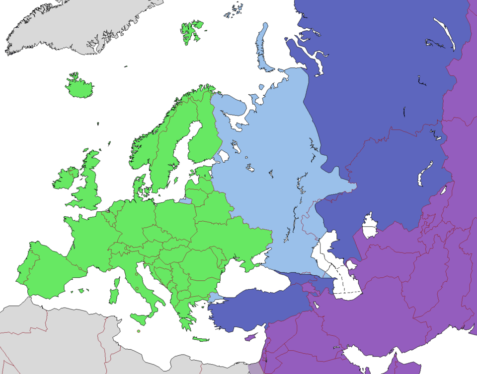
English: Map of Europe, indicating continental boundary and transcontinental states.
States geographically in Europe (excepting overseas possessions; island states UK, Ireland, Iceland and Malta usually grouped with the European continent)
Transcontinental states, European territory
Transcontinental states, Asian territory
Geographically Asian states (island states of Cyprus and Bahrain usually grouped with Asia geographically)
Asian part of Egypt |
| Sanasi | (UTC) |
| Manba | |
| Muallif |
|
| Other versions |
 |


 |
This is a retouched picture, which means that it has been digitally altered from its original version. Modifications: corrections, cropped, removed labels. The original can be viewed here: Europe subregion map UN geoschme.svg:  . Modifications made by Dbachmann.
|


Bu fayl Creative Commons asosida litsenziyalangan Attribution- Share Alike 3.0 Unported litsenziyasi.
- Siz erkinsiz:
- ulashishga – ishlanmani nusxalash, tarqatish va uzatish
- remiks qilishga – ishni moslashtirishga
- Quyidagi shartlar asosida:
- atribut – Siz tegishli litsenziyaga havolani taqdim etishingiz va oʻzgartirishlar kiritilganligini koʻrsatishingiz kerak. Siz buni har qanday oqilona yoʻl bilan qilishingiz mumkin, lekin litsenziar Sizni yoki Sizning foydalanishingizni ma'qullashini taklif qiladigan tarzda emas.
- bir xil ulashish – Agar Siz materialni remiks qilsangiz, oʻzgartirsangiz yoki unga asoslansangiz, oʻz hissalaringizni asl nusxadagi kabi bir xil yoki mos litsenziya ostida tarqatishingiz kerak.
Original upload log
This image is a derivative work of the following images:
- File:Map_of_Europe_(political).png licensed with Cc-by-sa-3.0-migrated, GFDL
- 2011-04-08T11:49:26Z Dbachmann 1596x1043 (72823 Bytes) rv to correct Caucasus crest. Reverted to version as of 02:17, 16 December 2009
- 2010-02-26T23:44:12Z Gumol 1596x1043 (73077 Bytes) Faroe Islands, Iceland and Jan Mayen changed to "Europe" since they are geologically located in Europe.
- 2009-12-17T19:21:01Z Kolja21 1596x1043 (109680 Bytes) rev. This is a different map. Please use disc. first
- 2009-12-16T02:17:05Z Izzedine 1596x1043 (72823 Bytes) Corrected Caucasian crest and labels
- 2009-11-13T19:16:35Z Kwamikagami 1596x1043 (109680 Bytes) m. spelling, add Canaries
- 2009-11-13T12:08:59Z Kwamikagami 1596x1043 (109658 Bytes) correct color coding per talk
- 2009-02-03T09:46:18Z Koyos 1596x1043 (110005 Bytes) reverting geographically inaccurate color coding
- 2008-07-18T13:16:24Z Aegean Boy 0x0 (110096 Bytes) {{Information |Description= |Source= |Date= |Author= |Permission= |other_versions= }}
- 2008-06-20T15:03:21Z Drieskamp 0x0 (110005 Bytes) {{Information |Description= |Source= |Date= |Author= |Permission= |other_versions= }}
- 2007-01-15T21:02:56Z Jon Harald Søby 0x0 (110089 Bytes) small change in Azerbaijan's colour
- 2006-12-03T14:06:17Z Electionworld 0x0 (117601 Bytes) {[ew|en|Alinor}} According to [[Transcontinental nation|one common view]] of the boundary, the European continent is the area coloured green on this map. The light blue/dark blue colors are described at [[Transcontinental nat
- File:Europe_subregion_map_UN_geoschme.svg licensed with Cc-by-3.0
- 2009-05-27T18:50:52Z Kolja21 680x520 (585185 Bytes) {{Information |Description={{en|1=Subregions of Europe ([[:en:United Nations geoscheme|UN geoschme]])}} {{de|1=Subregionen Europas (nach UN Geoschema)}} |Source=Eigenes Werk (own work) |Author=[[User:Kolja21|Kolja21]] |Date=2
Uploaded with derivativeFX
Fayl tarixi
Faylning biror paytdagi holatini koʻrish uchun tegishli sana/vaqtga bosingiz.
| Sana/Vaqt | Miniatura | Oʻlchamlari | Foydalanuvchi | Izoh | |
|---|---|---|---|---|---|
| joriy | 16:52, 2022-yil 29-avgust | | 1 268 × 996 (47 KB) | wikimediacommons>Рагин1987 | Small correction |
Fayllarga ishoratlar
Bu faylga quyidagi sahifa bogʻlangan:
