
Fayl:Deserts.png

Bu prevyuning hajmi: 800 × 267 piksel. Boshqa oʻlchamlari: 2 184 × 728 piksel.
Asl fayl (2 184 × 728 piksel, fayl hajmi: 1,39 MB, MIME tipi: image/png)

Qisqa izoh
| Taʼrif |
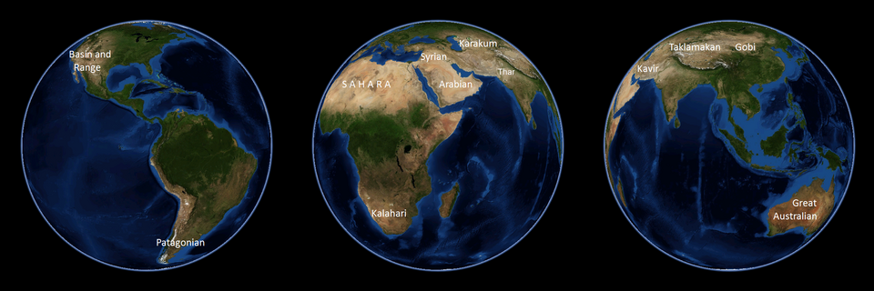
English: NASA World Wind 1.4 used. Note that the polar regions, not highlighted in this image, are the largest areas on the planet with little precipitation and are technically considered to be deserts themselves. |
| Sanasi | 5 aprel 2009 (original upload date) |
| Manba | Transferred from en.wikipedia to Commons by Common Good using CommonsHelper. |
| Muallif | Emilfaro at inglizcha Vikipediya |
| Other versions | العربيَّة |

Litsenziyalash

|
This work has been released into the public domain by its author, Emilfaro at inglizcha Vikipediya. This applies worldwide. In some countries this may not be legally possible; if so: Emilfaro grants anyone the right to use this work for any purpose, without any conditions, unless such conditions are required by law. |
|
This image is in the public domain because it is a screenshot from NASA’s globe software World Wind using a public domain layer, such as Blue Marble, MODIS, Landsat, SRTM, USGS or GLOBE.
|
 |
Original upload log
The original description page was here. All following user names refer to en.wikipedia.

- 2009-04-05 10:23 Spudtater 2184×728× (1444057 bytes) Tyop
- 2009-04-05 10:21 Spudtater 2184×728× (1444046 bytes) arg!
- 2009-04-05 10:18 Spudtater 2184×728× (1444075 bytes) Tyop
- 2008-10-01 23:12 Emilfaro 2184×728× (1444046 bytes) NASA World Wind 1.4 used.
Fayl tarixi
Faylning biror paytdagi holatini koʻrish uchun tegishli sana/vaqtga bosingiz.
| Sana/Vaqt | Miniatura | Oʻlchamlari | Foydalanuvchi | Izoh | |
|---|---|---|---|---|---|
| joriy | 16:07, 2023-yil 18-sentyabr | | 2 184 × 728 (1,39 MB) | wikimediacommons>PadFoot2008 | Added missing Thar desert. |
Fayllarga ishoratlar
Bu faylga quyidagi sahifa bogʻlangan:
