
Fayl:Canada topo.jpg

Bu prevyuning hajmi: 693 × 599 piksel. Boshqa oʻlchamlari: 1 400 × 1 211 piksel.
Asl fayl (1 400 × 1 211 piksel, fayl hajmi: 791 KB, MIME tipi: image/jpeg)

Qisqa izoh
| Taʼrif |
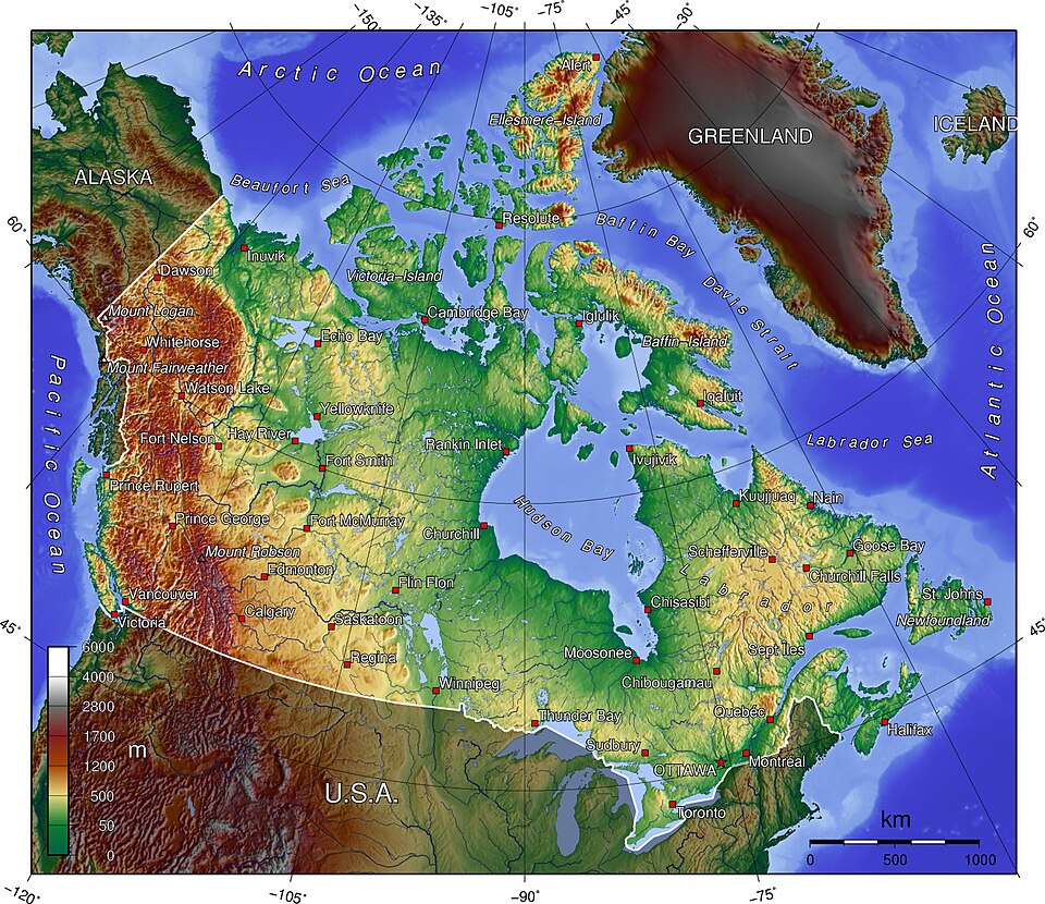
A topographic map of Canada, in polar projection (for 90° W), showing elevations shaded from green to brown (higher), with elevation-legend overlaid at lower left. Nearby countries are shaded darker (compare elevation shades at Canadian borders). The image is centered over longitude 90° W, with longitude meridians at 15-degree intervals apart, and latitude parallels also 15-degree. The boundaries are roughly from longitude 10°W to 177°W, and latitude 40°N to 84°N (above northern-most Alert, Canada 82°28′N, 62°30′W). |
| Sanasi | 14-April-2006 (English Wikipedia image of 7-July-2005) |
| Manba | From English Wikipedia image of 7-July-2005, same name: en:Image:Canada topo.jpg (which now points here to Commons). |
| Muallif | User:Anchjo (from en:Wikipedia User:Captain_Blood) |
| Other versions | Derivative works of this file: Dawson Route topo.jpg |


Litsenziyalash
 |
The map has been created with the Generic Mapping Tools: https://www.generic-mapping-tools.org/ using one or more of these public-domain datasets for the relief:
|

|
Ushbu hujjatdan nusxa ko‘chirish, tarqatish va/yoki o‘zgartirish uchun GNU Erkin guvohnoma litsenziyasi (GNU Free Documentation License), 1.2 va har qanday keyingi versiyalar shartlariga muvofiq ruxsat berilgan yoki Ochiq kodli dasturlar jamiyati (Free Software Foundation) tomonidan chop etilgan; oʻzgarmas boʻlimlarsiz, oldingi muqova matnlari va orqa muqova matnlarisiz. Litsenziya nusxasi GNU Erkin guvohnoma litsenziyasi (GNU Free Documentation License) boʻlimiga kiritilgan. |
  
|
Bu fayl Creative Commons asosida litsenziyalangan Attribution- Share Alike 3.0 Unported litsenziyasi. | |
| ||
| This licensing tag was added to this file as part of the GFDL licensing update. |

Original upload log
- http://upload.wikimedia.org/wikipedia/en/d/d7/Canada topo.jpg[dead link] (14:36, 7 July 2005) . . User:Captain Blood (Captain Blood) (User talk:Captain Blood (Talk) ) . . 1400x1211 (810081 bytes) ({GMT})

Fayl tarixi
Faylning biror paytdagi holatini koʻrish uchun tegishli sana/vaqtga bosingiz.
| Sana/Vaqt | Miniatura | Oʻlchamlari | Foydalanuvchi | Izoh | |
|---|---|---|---|---|---|
| joriy | 19:22, 2006-yil 14-aprel | | 1 400 × 1 211 (791 KB) | wikimediacommons>Anchjo | '''This file was transfered from [http://en.wikipedia.org en.wikipedia.org]. The original file description page is (was) here.''' == Original description at [http://en.wikipedia.org en] == {{GFDL-GMT}} [[:de:Bild:Kanada_topo |
Fayllarga ishoratlar
Bu faylga quyidagi sahifa bogʻlangan:
