Kontent qismiga oʻtish

Fayl:Boston, 1775bsmall1.png

ZiyoSfera, erkin ensiklopediya
Asl fayl (2 480 × 3 500 piksel, fayl hajmi: 15,87 MB, MIME tipi: image/png)

Ushbu fayl Vikiomborga yuklangan boʻlib, boshqa loyihalarda ham qoʻllanilishi mumkin. Uning tavsif sahifasidan olingan maʼlumot quyida keltirilgan.

Vikipediya

 This is a featured picture on the English language Wikipedia (Featured pictures) and is considered one of the finest images. See its nomination here.
 This is a featured picture on the Turkish language Wikipedia (Seçkin resimler) and is considered one of the finest images. See its nomination here.

If you think this file should be featured on Wikimedia Commons as well, feel free to nominate it.
If you have an image of similar quality that can be published under a suitable copyright license, be sure to upload it, tag it, and nominate it.

This is a retouched picture, which means that it has been digitally altered from its original version. Modifications: dirt and stains removed, levels and color adjusted; slightly cropped and rotated. The original can be viewed here: Boston, 1775small1.png: . Modifications made by Durova.

Qisqa izoh

Taʼrif
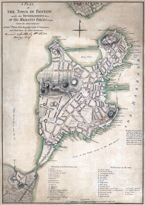
English: A plan of the town of Boston with the intrenchments &ca. of His Majesty's forces in 1775, from the observations of Lieut. Page of His Majesty's Corps of Engineers, and from those of other gentlemen."
العربية: خريطة تظهر تقييم ميداني بريطاني لبوسطن في عام 1775.
Sanasi
Manba
This map is available from the United States Library of Congress's Geography & Map Division
under the digital ID g3764b.ct000250.
This tag does not indicate the copyright status of the attached work. A normal copyright tag is still required. See Commons:Licensing.

العربية ∙ беларуская (тарашкевіца) ∙ বাংলা ∙ čeština ∙ Deutsch ∙ English ∙ español ∙ فارسی ∙ suomi ∙ français ∙ galego ∙ עברית ∙ magyar ∙ Bahasa Indonesia ∙ Ido ∙ italiano ∙ 日本語 ∙ Bahaso Melayu Jambi ∙ lietuvių ∙ македонски ∙ മലയാളം ∙ Nederlands ∙ polski ∙ português ∙ português do Brasil ∙ română ∙ русский ∙ sicilianu ∙ slovenčina ∙ slovenščina ∙ Türkçe ∙ українська ∙ 中文 ∙ 中文(简体) ∙ 中文(繁體) ∙ +/−

Muallif
Thomas Hyde Page (1746–1821)  wikidata:Q7790947
 
Thomas Hyde Page
Alternative names
Sir Thomas Hyde Page
Description British military engineer va cartographer
Date of birth/death 1746 Edit this at Wikidata 30 iyun 1821 Edit this at Wikidata
Location of birth/death Boulogne-sur-Mer Edit this at Wikidata
Hokimiyat nazorati
creator QS:P170,Q7790947

Litsenziyalash

Public domain
This work is in the public domain in the United States because it was published (or registered with the U.S. Copyright Office) before January 1, 1931.
Public domain This work is from the Library of Congress. According to the library, there are no known copyright restrictions on the use of this work.

Captions

Add a one-line explanation of what this file represents
American Revolution. 1775 British Occupation of Boston. Map by British Officer.

Items portrayed in this file

tasvirlangan obyekt

image/png

checksum inglizcha

d43019db036aec09b015944fb4cb7de1fb216a8d

data size inglizcha

16 640 674 Bayt

3 500 piksel

width inglizcha

2 480 piksel

Fayl tarixi

Faylning biror paytdagi holatini koʻrish uchun tegishli sana/vaqtga bosingiz.

Sana/VaqtMiniaturaOʻlchamlariFoydalanuvchiIzoh
joriy05:01, 2008-yil 17-iyul05:01, 2008-yil 17-iyul dagi versiya uchun tasvir2 480 × 3 500 (15,87 MB)wikimediacommons>Durova{{Information |Description="A plan of the town of Boston with the intrenchments &ca. of His Majesty's forces in 1775, from the observations of Lieut. Page of His Majesty's Corps of Engineers, and from those of other gentlemen." |Source=Library of Congress

Bu faylga quyidagi sahifa bogʻlangan: