
Fayl:Asia 400ad.jpg

Bu prevyuning hajmi: 800 × 487 piksel. Boshqa oʻlchamlari: 1 990 × 1 211 piksel.
Asl fayl (1 990 × 1 211 piksel, fayl hajmi: 790 KB, MIME tipi: image/jpeg)

|
This historical map image could be re-created using vector graphics as a SVG file. This has several advantages; see Commons:Media for cleanup for more information. If a SVG form of this image is available, please upload it and afterwards replace this template with
{{vector version available|new image name}}.It is recommended to name the SVG file “Asia 400ad.svg”—then the template Vector version available (or Vva) does not need the new image name parameter. |


Qisqa izoh
| Taʼrif |
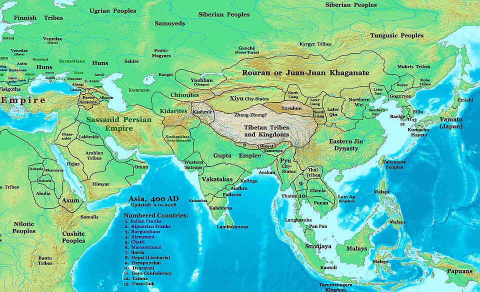
English: Asia in 400 AD. Displayed among others: Kushan Empire, Sassanid Empire, Gupta Empire, Huns, Tai peoples, Kidarites |
| Manba | URL: http://www.ThomasLessman.com/History/images/East-Hem_400ad.jpg |
| Muallif | Thomas A. Lessman, en:User:Talessman |
| Ruxsat (Bu faylning takror foydalanilishi) |
Image was created by me (Thomas Lessman) based on map of Eastern Hemisphere in 400 AD. Image is free for public and/or educational use. I would appreciate a mention if this image is used elsewhere. If anyone is interested in helping further this work, please contact Thomas Lessman at talessman@yis.us. |
| Other versions | Derivative works of this file: |




|
|
This historical map image could be re-created using vector graphics as a SVG file. This has several advantages; see Commons:Media for cleanup for more information. If a SVG form of this image is available, please upload it and afterwards replace this template with
{{vector version available|new image name}}.It is recommended to name the SVG file “Asia 400ad.svg”—then the template Vector version available (or Vva) does not need the new image name parameter. |
Litsenziyalash
  
|
Bu fayl Creative Commons asosida litsenziyalangan Attribution- Share Alike 3.0 Unported litsenziyasi. Subject to disclaimers. | |
| ||
| This licensing tag was added to this file as part of the GFDL licensing update. |

|
Ushbu hujjatdan nusxa ko‘chirish, tarqatish va/yoki o‘zgartirish uchun GNU Erkin guvohnoma litsenziyasi (GNU Free Documentation License), 1.2 va har qanday keyingi versiyalar shartlariga muvofiq ruxsat berilgan yoki Ochiq kodli dasturlar jamiyati (Free Software Foundation) tomonidan chop etilgan; oʻzgarmas boʻlimlarsiz, oldingi muqova matnlari va orqa muqova matnlarisiz. Litsenziya nusxasi GNU Erkin guvohnoma litsenziyasi (GNU Free Documentation License) boʻlimiga kiritilgan. Subject to disclaimers. |
Fayl tarixi
Faylning biror paytdagi holatini koʻrish uchun tegishli sana/vaqtga bosingiz.
| Sana/Vaqt | Miniatura | Oʻlchamlari | Foydalanuvchi | Izoh | |
|---|---|---|---|---|---|
| joriy | 23:27, 2008-yil 6-aprel | | 1 990 × 1 211 (790 KB) | wikimediacommons>Guillem d'Occam | Author: Thomas A. Lessman. Source URL: [http://www.ThomasLessman.com/History/images/East-Hem_400ad.jpg]. Image was created by me (Thomas Lessman) based on map of Eastern Hemisphere in 400 AD. Image is free for public and/or educational use. I would appr |
Fayllarga ishoratlar
Bu faylga quyidagi 2 sahifalar bogʻlangan:
