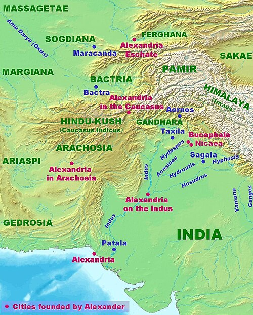
Fayl:AlexanderIndiaMap.jpg
Qiyofa
ZiyoSfera, erkin ensiklopediya
Bu prevyuning hajmi: 480 × 599 piksel. Boshqa oʻlchamlari: 1 112 × 1 388 piksel.
Asl fayl (1 112 × 1 388 piksel, fayl hajmi: 275 KB, MIME tipi: image/jpeg)
Ushbu fayl Vikiomborga yuklangan boʻlib, boshqa loyihalarda ham qoʻllanilishi mumkin. Uning tavsif sahifasidan olingan maʼlumot quyida keltirilgan.
Qisqa izoh
| TaʼrifAlexanderIndiaMap.jpg |
English: Map of Alexander's campaigns in India. Personal creation 2007. Reference "Diodorus of Sicily", Harvard University Press. |
| Sanasi | 14 yanvar 2007 (original upload date) |
| Manba |
Own work using:
|
| Muallif | No machine-readable author provided. World Imaging assumed (based on copyright claims). |
This historical map image could be re-created using vector graphics as a SVG file. This has several advantages; see Commons:Media for cleanup for more information. If a SVG form of this image is available, please upload it and afterwards replace this template with
{{vector version available|new image name}}.It is recommended to name the SVG file “AlexanderIndiaMap.svg”—then the template Vector version available (or Vva) does not need the new image name parameter. |
This historical map image was uploaded in the JPEG format even though it consists of non-photographic data. This information could be stored more efficiently or accurately in the PNG or SVG format. If possible, please upload a PNG or SVG version of this image without compression artifacts, derived from a non-JPEG source (or with existing artifacts removed). After doing so, please tag the JPEG version with {{Superseded|NewImage.ext}} and remove this tag. This tag should not be applied to photographs or scans. If this image is a diagram or other image suitable for vectorisation, please tag this image with {{Convert to SVG}} instead of {{BadJPEG}}. If not suitable for vectorisation, use {{Convert to PNG}}. For more information, see {{BadJPEG}}. |
Litsenziyalash
| Public domainPublic domainfalsefalse |
| I, the copyright holder of this work, release this work into the public domain. This applies worldwide. In some countries this may not be legally possible; if so: I grant anyone the right to use this work for any purpose, without any conditions, unless such conditions are required by law. |
| Annotations InfoField | This image is annotated: View the annotations at Commons |
Captions
Add a one-line explanation of what this file represents
Sagala, l'autre nom d'Euthymedeia, située à l'Est des villes de Nicaea et Bucephala fondées par Alexandre lors de sa campagne en Inde.
Items portrayed in this file
tasvirlangan obyekt
14 yanvar 2007
image/jpeg
checksum inglizcha
809c0cc3494b608632dbb4baa07fb90005566999
data size inglizcha
281 457 Bayt
1 388 piksel
width inglizcha
1 112 piksel
Fayl tarixi
Faylning biror paytdagi holatini koʻrish uchun tegishli sana/vaqtga bosingiz.
| Sana/Vaqt | Miniatura | Oʻlchamlari | Foydalanuvchi | Izoh | |
|---|---|---|---|---|---|
| joriy | 22:22, 2022-yil 1-sentyabr | 1 112 × 1 388 (275 KB) | wikimediacommons>Ras67 | less tight crop |
Fayllarga ishoratlar
Bu faylga quyidagi sahifa bogʻlangan:
Metama’lumot
Bu fayl qoʻshimcha maʼlumotlarni oʻz ichiga oladi, ehtimol uni tuzish yoxud raqamlashtirish uchun raqamli kamera yoki skanerdan foydalanilgan.
Agar fayl asl holatidan oʻzgartirilgan boʻlsa, baʼzi tafsilotlar oʻzgartirilgan faylni toʻliq aks ettirmasligi mumkin.
| User comments | : Microsoft Office |
|---|
"https://ziyosfera.uz/ziyo/Fayl:AlexanderIndiaMap.jpg" dan olindi