
Fayl:Alania 10th–12th c. according to Bzarov.png
Asl fayl (1 656 × 1 281 piksel, fayl hajmi: 83 KB, MIME tipi: image/png)


Qisqa izoh
| Taʼrif |
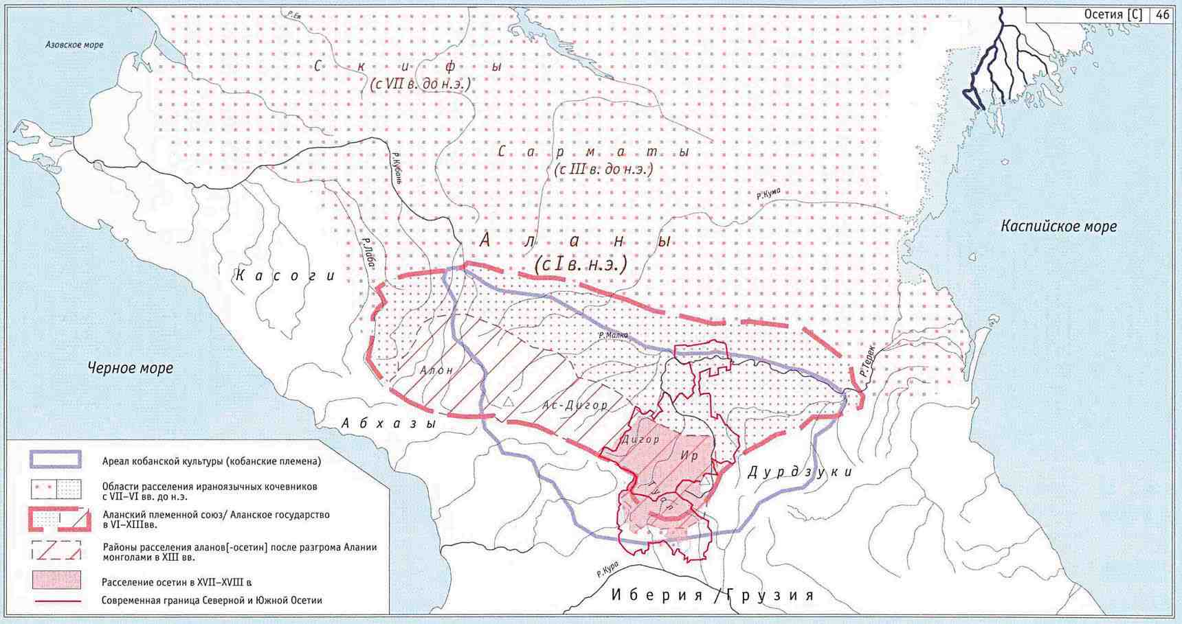
English: Borders of modern North Ossetia (Alania) and South Ossetia compared with borders of medieval Alania (10th-12th century) - according to Ossetian historian Ruslan Suleymanovich Bzarov. |
||
| Sanasi | 6 iyun 2009 (original upload date) | ||
| Manba | No machine-readable source provided. Own work assumed (based on copyright claims). | ||
| Muallif | No machine-readable author provided. WikiEditor2004 assumed (based on copyright claims). | ||
| Other versions |
|


Sources
Made according to these history maps from internet:
- map from www.alanica.ru: http://www.alanica.ru/images/map/alan3.jpgarchive copy at the Wayback Machine - the map is linked from this page: http://www.alanica.ru/map/index.htm[dead link] - according to that page, these maps originally came from this book: "Исторический атлас Осетии" (Отв. ред. Р.С. Бзаров)., Владикавказ, изд. "Ремарко", 2002 г. - here is translation of this page into English: http://translate.google.com/translate?hl=en&sl=ru&u=http://www.alanica.ru/map/index.htm&ei=cy1aSq3NHpLFsga6rInWAw&sa=X&oi=translate&resnum=8&ct=result&prev=/search%3Fq%3D%25D0%2591%25D0%25B7%25D0%25B0%25D1%2580%25D0%25BE%25D0%25B2%2B%25D0%25B0%25D1%2582%25D0%25BB%25D0%25B0%25D1%2581%26hl%3Den%26sa%3DG and English name of the original book source: "Historical Atlas of Ossetia (Отв. Ed. Bzarov RS)., Vladikavkaz, ed." Remarque ", 2002
- map from www.aors.narod.ru: http://www.aors.narod.ru/images/Al-VII.gif - the map is linked from this page: http://www.aors.narod.ru/Texty/AlyVII-XII.htm Here is bibliography of this web site: http://www.aors.narod.ru/Texty/Istochniki.htm - history maps probably came from this history atlas listed in bibliography: "Исторический атлас Осетии / Отв. ред. Р.С. Бзаров - Владикавказ: Ремарко, 2002 - 48 с. ил."
- map from iratta.com: http://iratta.com/uploads/posts/atlas/09/karta.jpg - the map is linked from this page: http://iratta.com/2007/03/03/alanija_v_viixii_vv.html
- map from fandag.ru: http://fandag.ru/load/9-1-0-56
- map from www.iriston.com: http://www.iriston.com/books/cuciev_-_etno_atlas/maps/map46.jpg (Ethno Atlas, Cuciev)


Litsenziyalash
self-made map by WikiEditor2004

|
I, the copyright holder of this work, release this work into the public domain. This applies worldwide. In some countries this may not be legally possible; if so: I grant anyone the right to use this work for any purpose, without any conditions, unless such conditions are required by law. |
Fayl tarixi
Faylning biror paytdagi holatini koʻrish uchun tegishli sana/vaqtga bosingiz.
| Sana/Vaqt | Miniatura | Oʻlchamlari | Foydalanuvchi | Izoh | |
|---|---|---|---|---|---|
| joriy | 13:54, 2020-yil 18-aprel | Miniatyurasi yoʻq | 1 656 × 1 281 (83 KB) | wikimediacommons>WikiEditor2004 | Reverted to version as of 19:47, 26 April 2014 (UTC) - please upload your version under different filename |
Fayllarga ishoratlar
Bu faylga quyidagi sahifa bogʻlangan:
