
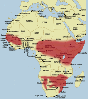
Fayl:Africa land cover location mamba map with borders.jpg

Bu prevyuning hajmi: 635 × 600 piksel. Boshqa oʻlchamlari: 1 525 × 1 440 piksel.
Asl fayl (1 525 × 1 440 piksel, fayl hajmi: 928 KB, MIME tipi: image/jpeg)
Qisqa izoh
| Taʼrif |
English: Map of geographical range of the black mamba in Africa. Source of information displayed is this or more specifically this linked file. |
||
| Sanasi | March 12, 2019 based on earlier version published 28 noyabr 2013, 05:10:11 (upload date); the source data displays a file modified date of March 22, 2013 | ||
| Manba | File:Africa location map black mamba distribution.svg overlaid on File:Africa location map.svg | ||
| Muallif | Samsara using work by Sameboat and Sting | ||
| Ruxsat (Bu faylning takror foydalanilishi) |
   Bu fayl Creative Commons asosida litsenziyalangan Attribution- Share Alike 3.0 Unported litsenziyasi.
Siz oʻzingiz xohlagan litsenziyani tanlashingiz mumkin. |




Fayl tarixi
Faylning biror paytdagi holatini koʻrish uchun tegishli sana/vaqtga bosingiz.
| Sana/Vaqt | Miniatura | Oʻlchamlari | Foydalanuvchi | Izoh | |
|---|---|---|---|---|---|
| joriy | 02:01, 2019-yil 13-mart | | 1 525 × 1 440 (928 KB) | wikimediacommons>Samsara | {{Information |description ={{en|1=Map of geographical range of the black mamba in Africa. Source of information displayed is [http://www.toxinology.com/fusebox.cfm?fuseaction=main.snakes.display&id=SN0170 this] or more specifically [http://www.toxinology.com/images/snakes/SNMS0170.gif this linked file].}} |date =March 12, 2019 based on earlier version published {{Upload date|2013-11-28 05:10:11}}; the source data displays a file modified date of March 22, 2013 |source =[[:F... |
Fayllarga ishoratlar
Bu faylga quyidagi sahifa bogʻlangan:
