
Afgʻonistondagi zilzilalar roʻyxati
<mapframe>: Title "Earthquakes in Afghanistan 1900-.map" is not a valid map data page
Bu Afgʻonistondagi zilzilalar roʻyxati. Oʻrtacha darajadagi zilzilalar ham mamlakatda, ayniqsa 21-asr davomida juda katta vayronagarchiliklarga sabab boʻlgan. Aholining katta qismi zilzilalarga bardoshsiz boʻlgan norasmiy va paxsa uylarda istiqomat qiladi.[1]
Tektonik holat
Afgʻoniston Yevroosiyo plitasining janubiy chekkasiga yaqin joylashgan.[2]
Zilzilalar
| Sana | Joy | Kengl | Uzunl | Qurbonlar | Jarohatlanganlar | Magnituda | MMI | Izohlar | |
|---|---|---|---|---|---|---|---|---|---|
| 2025-11-03 | Balx | 36.589 | 67.484 | 31 | 1,156 | 6.2 | VII | [3] | |
| 2025-09-04 | Kunar | 34.719 | 70.791 | 2 | 41 | 5.6 | VIII | Aftershok (Asosiy zilziladan keyingi silkinish) | [4][5] |
| 2025-08-31 | Kunar | 34.519 | 70.734 | 3,000 | 4,000 | 6.0 | IX | Haddan tashqari vayronagarchilik | [6] |
| 2023-10-07 | Hirot | 34.610 | 61.924 | 1,489 | 2,444 | 6.3 | VIII | Toʻrtta zilzila va aftershoklar/Haddan tashqari vayronagarchilik. | [7] |
| 2023-03-21 | Badaxshon | 36.523 | 70.979 | 21 | 424 | 6.5 | V | Oʻrtacha zarar, 21 ta oʻlim, shundan 10 tasi Pokistonda. | [8] |
| 2022-09-06 | Badaxshon | 36.649 | 70.629 | 6 | 9 | 4.8 | III | Yana zarar yetgan | [9] |
| 2022-09-04 | Kunar | 34.662 | 70.701 | 18 | 42 | 5.1 | VII | Oʻrtacha zarar | [10] |
| 2022-07-18 | Xost | 33.108 | 69.470 | 44 | 5.1 | V | Qoʻshimcha zarar / aftershok | [11] | |
| 2022-06-24 | Xaybar-Paxtunxva, Pokiston | 33.017 | 69.538 | 5 | 11 | 4.2 | VII | Barcha oʻlimlar Afgʻonistonda / aftershok | [12] |
| 2022-06-21 | Xost | 33.092 | 69.514 | 1,163 | 2,976 | 6.2 | IX | Haddan tashqari vayronagarchilik/koʻchkilar | [13] |
| 2022-05-24 | Hindukush | 36.118 | 70.293 | 2 | 1 | 4.9 | VI | Kichik zarar | [14] |
| 2022-02-05 | Hindukush | 36.445 | 71.117 | 3 | 5.8 | IV | [15] | ||
| 2022-01-17 | Bodgʻis | 34.946 | 63.580 | 30 | 49 | 5.3 | VI | [16] | |
| 2018-01-31 | Hindukush | 36.54 | 70.82 | 2 | 22 | 6.1 Mw | IV | ||
| 2016-04-10 | Ishkoshim | 6 | 28 | 6.6 Mw | V | ||||
| 2015-10-26 | Hindukush | 36.52 | 70.37 | 399 | 2,536 | 7.5 Mw | VII | ||
| 2013-04-24 | Jalolobod-Mehtar Lam | 34.53 | 70.22 | 18 | 130 | 5.6 Mw | V | [17] | |
| 2012-06-11 | Bagʻlon | 36.05 | 69.30 | 75 | - | 5.4, 5.7 | V | Doublet | [18] |
| 2010-04-18 | Samangan | 35.71 | 67.68 | 11 | - | 5.6 | VI | [19] | |
| 2009-10-22 | Hindukush | 36.52 | 70.95 | 5 | - | 6.2 | V | [20] | |
| 2009-04-16 | Kobul yaqinida | 34.19 | 70.08 | 19 | 51 | 5.2 {{w}} | VI | Doublet | |
| 2005-12-12 | Hindukush | 36.28 | 71.11 | 5 | 1 | 6.5 Mw | V | ||
| 2002-03-25 | Hindukush | 35.93 | 69.19 | 2,000 | 3,000 | 6.1 Mw | VII | ||
| 2002-03-03 | Hindukush | 36.5 | 70.48 | 166 | Biroz | 7.4 Mw | VI | ||
| 1999-02-11 | Kobul | 34.3 | 69.36 | 70 | 500 | 6.0 Mw | VI | [21] | |
| 1998-05-30 | Taxar | 37.17 | 70.09 | 4,000–4,500 | 10,001 | 6.5 Mw | VI | ||
| 1998-02-04 | Taxar | 37.17 | 70.14 | 2,323 | 818 | 5.9 Mw | VI | ||
| 1994-05-01 | Mozori Sharif | 36.901 | 67.163 | 160 | 330 | 6.1 {{w}} | Ogʻir zarar | [22] | |
| 1991-04-20 | Badaxshon | 36.416 | 70.912 | 4.1 {{w}} | III | 100 ta uy zarar koʻrgan | [23] | ||
| 1991-04-08 | Badaxshon | 37.457 | 68.273 | 1 | 6 | 5.5 {{w}} | VII | Oʻrtacha zarar | [24] |
| 1991-01-31 | Hindukush | 35.99 | 70.42 | 848 | 200 | 6.9 Mw | VII | Haddan tashqari vayronagarchilik | [25] |
| 1990-07-13 | Hindukush | 36.415 | 70.789 | 43 | 2 | 6.4 {{w}} | IV | Tojikistonda qor koʻchkisi oqibatidagi oʻlimlar. | [26] |
| 1985-07-29 | Hindukush | 36.190 | 70.896 | 5 | 38 | 7.4 {{w}} | VIII | Pokiston va Tojikistonda ham jiddiy zarar. | [27] |
| 1984-02-16 | Hindukush | 36.431 | 70.826 | 4 | 13 | 6.4 {{w}} | IV | Jiddiy zarar | [28] |
| 1984-02-01 | Nangarhor | 34.616 | 70.484 | 1 | 35 | 6.1 | VII | Kichik zarar | [29] |
| 1983-12-31 | Hindukush | 36.37 | 70.34 | 12–26 | 60–483 | 7.2 Mb | VII | Jiddiy zarar | [30] |
| 1982-12-16 | Bagʻlon | 36.148 | 69.011 | 450 | Koʻp | 6.6 {{s}} | VI | Jiddiy zarar | [31] |
| 1981-06-13 | Samangan | 36.176 | 67.827 | 1 | 2 | 5.5 {{w}} | VI | [32] | |
| 1956-09-16 | Logar | 33.997 | 69.667 | 6.5 {{w}} | VIII | [33] | |||
| 1956-06-09 | Bomiyon | 35.155 | 67.607 | 570–900 | 2,000–2,500 | 7.3 {{w}} | VII | Mamlakat boʻylab keng sezilgan | [34] |
| 1921-11-15 | Hindukush | 36.202 | 70.711 | 7.8 {{w}} | V | [35] | |||
| 1842-02-19 | Jalolobod | 34.4 | 70.5 | 500 | Jiddiy zarar | [36] | |||
| 818-05-15 | Hindukush | 36.8 | 66.2 | Koʻp | 7.5 Ms | VIII | Jiddiy zarar | [37] | |
| Eslatma: Hodisalarni qoʻshish mezonlari Zilzilalar Vikiloyihasining mustaqil maqolalar uchun ishlab chiqilgan ahamiyatlilik koʻrsatmalariga asoslanadi. Bayon etilgan tamoyillar roʻyxatlarga ham tegishli. Xulosa qilib aytganda, faqat zarar keltirgan, jarohatlanishga yoki oʻlimga sabab boʻlgan hodisalargina qayd etilishi kerak. | |||||||||
Galereya
-
 2022-yil iyundagi Afgʻoniston zilzilasi natijasida Xost viloyatida qulagan uy.
-
 2023-yilgi Hirot zilzilasi natijasida Hirotda vayron boʻlgan qishloq.
-
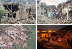 2025-yilgi Kunar zilzilasi natijasida Kunar viloyatidagi ogʻir vayronagarchilik.
-
 2025-yilgi Balx zilzilasi natijasida Samangan viloyatidagi uylarga yetgan zarar.


Shuningdek qarang
Manbalar
- ↑ „PAGER“. United States Geological Survey (2022-yil 21-iyun). Qaraldi: 2022-yil 1-dekabr.
- ↑ Ambraseyes, N.; Bilham, R. (2003), „Earthquakes in Afghanistan“, Seismological Research Letters, 74 (2): 107, Bibcode:2003SeiRL..74..107A, doi:10.1785/gssrl.74.2.107
- ↑ Lua xatosi in Modul:Cite at line 60: attempt to call field '_citation' (a nil value).
- ↑ Lua xatosi in Modul:Cite at line 60: attempt to call field '_citation' (a nil value).
- ↑ Sirat, Siyar. „Sources: One dead, 22 injured in new earthquake in eastern Afghanistan“. Amu Television (2025-yil 4-sentyabr). Qaraldi: 2025-yil 4-sentyabr.
- ↑ Lua xatosi in Modul:Cite at line 60: attempt to call field '_citation' (a nil value).
- ↑ Health Cluster; World Health Organization. „Afghanistan Earthquake in Herat Province, Health Situation Report No. 4 10 October 2023“. ReliefWeb (2023-yil 10-oktyabr). 2023-yil 11-oktyabrda asl nusxadan arxivlangan. Qaraldi: 2023-yil 11-oktyabr.
- ↑ „M 6.5 – 40 km SSE of Jurm, Afghanistan“. United States Geological Survey (2023-yil 21-mart). Qaraldi: 2023-yil 24-mart.
- ↑ „M 4.8 – 30 km SW of Jurm, Afghanistan“. United States Geological Survey (2022-yil 2-sentyabr).
- ↑ „M 5.3 – 34 km NE of Jalālābād, Afghanistan“. United States Geological Survey. Qaraldi: 2022-yil 5-sentyabr.
- ↑ „M 5.1 – 49 km WNW of Khōst, Afghanistan“. United States Geological Survey. Qaraldi: 2022-yil 18-iyul.
- ↑ „M 4.3 – 49 km W of Miran Shah, Pakistan“. United States Geological Survey. Qaraldi: 2022-yil 24-iyun.
- ↑ „M 5.9 – 46 km SW of Khōst, Afghanistan“. United States Geological Survey. Qaraldi: 2022-yil 22-iyun.
- ↑ „M 5.0 – 63 km SE of Farkhār, Afghanistan“. United States Geological Survey.
- ↑ „M 5.7 – 45 km SW of Ashkāsham, Afghanistan“. United States Geological Survey.
- ↑ „M 5.3 – 41 km E of Qala i Naw, Afghanistan“. United States Geological Survey.
- ↑ „67 Significant Earthquakes where Country = AFGHANISTAN“. Qaraldi: 2024-yil 21-mart.
- ↑ „Afghan quakes: Landslide killed 80, says governor“. BBC News (2012-yil 12-iyun). Qaraldi: 2012-yil 12-iyun.
- ↑ „M5.6 – central Afghanistan“. United States Geological Survey.
- ↑ „M6.2 – Hindu Kush region, Afghanistan“. United States Geological Survey.
- ↑ „M 6.0 – 27 km WNW of ?uk?mat? Azrah, Afghanistan“. United States Geological Survey.
- ↑ „M 6.1 – Central Afghanistan“. United States Geological Survey. Qaraldi: 2024-yil 15-may.
- ↑ „M 4.1 – 50 km S of Jurm, Afghanistan“. United States Geological Survey.
- ↑ „M 5.5 – 14 km ESE of Boshchorbogh, Tajikistan“. United States Geological Survey.
- ↑ NGDC 1972
- ↑ „M 6.4 – 50 km S of Jurm, Afghanistan“. United States Geological Survey. Qaraldi: 2021-yil 13-oktyabr.
- ↑ „M 7.4 – 75 km S of Jurm, Afghanistan“. United States Geological Survey. Qaraldi: 2021-yil 2-noyabr.
- ↑ „M 6.4 – 48 km S of Jurm, Afghanistan“. United States Geological Survey. Qaraldi: 2021-yil 2-noyabr.
- ↑ „M 6.1 – 21 km N of Jal?l?b?d, Afghanistan“. United States Geological Survey. Qaraldi: 2021-yil 2-noyabr.
- ↑ NGDC 1972
- ↑ „M 6.6 – 14 km NW of Nahr?n, Afghanistan“. United States Geological Survey. Qaraldi: 2021-yil 2-noyabr.
- ↑ „M 5.5 – 19 km WSW of Aībak, Afghanistan“. United States Geological Survey. Qaraldi: 2023-yil 3-may.
- ↑ Lua xatosi in Modul:Cite at line 60: attempt to call field '_citation' (a nil value).
- ↑ Lua xatosi in Modul:Cite at line 60: attempt to call field '_citation' (a nil value).
- ↑ „M 7.8 – Hindu Kush region, Afghanistan“. United States Geological Survey (1921-yil 15-noyabr). Qaraldi: 2021-yil 2-noyabr.
- ↑ NGDC 1972
- ↑ NGDC 1972
- NGDC (1972), Significant Earthquake Database (Data Set), National Geophysical Data Center, NOAA, doi:10.7289/V5TD9V7K
Qoʻshimcha oʻqish
- Ambraseys, N.; Bilham, R. (2003), „Earthquakes in Afghanistan“, Seismological Research Letters, 74 (2): 107–123, Bibcode:2003SeiRL..74..107A, doi:10.1785/gssrl.74.2.107, ISSN 0895-0695
- Rehman, Khaista; Ali, Wajid; Ali, Asghar; Ali, Aamir; Barkat, Adnan (2017), „Shallow and intermediate depth earthquakes in the Hindu Kush region across the Afghan-Pakistan border“, Journal of Asian Earth Sciences, 148: 241–253, Bibcode:2017JAESc.148..241R, doi:10.1016/j.jseaes.2017.09.005, ISSN 1367-9120
- Stenz, Edward (1945), „Strong Earthquakes in Afghanistan“, Bulletin of the Polish Institute of Arts and Sciences in America, 3 (2): 398–411, JSTOR 24724993
- Wheeler, Russell L. 2005. Seismotectonic Map of Afghanistan, with Annotated Bibliography [electronic Resource] / by Russell L. Wheeler … [et Al.] ; Prepared Under the Auspices of the U. S. Agency for International Development, U. S. Department of the Interior, U. S. Geological Survey. Reston, Va: U. S. Dept. of the Interior, U. S. Geological Survey.